You are here: Home > Network List > CO - South Carolina Seismic Network Stations List
> Station HODGE Hodges, SC, USA > Earthquake Result Viewer
HODGE Hodges, SC, USA - Earthquake Result Viewer
| Earthquake location: |
Kuril Islands |
| Earthquake latitude/longitude: |
46.2/150.8 |
| Earthquake time(UTC): |
2013/04/19 (109) 03:05:52 GMT |
| Earthquake Depth: |
110 km |
| Earthquake Magnitude: |
7.2 MW, 7.1 MB, 7.2 MW |
| Earthquake Catalog/Contributor: |
NEIC PDE/NEIC PDE-W |
|
| Network: |
CO South Carolina Seismic Network |
| Station: |
HODGE Hodges, SC, USA |
| Lat/Lon: |
34.23 N/82.26 W |
| Elevation: |
151 m |
|
| Distance: |
86.7 deg |
| Az: |
41.543 deg |
| Baz: |
326.238 deg |
| Ray Param: |
0.04360834 |
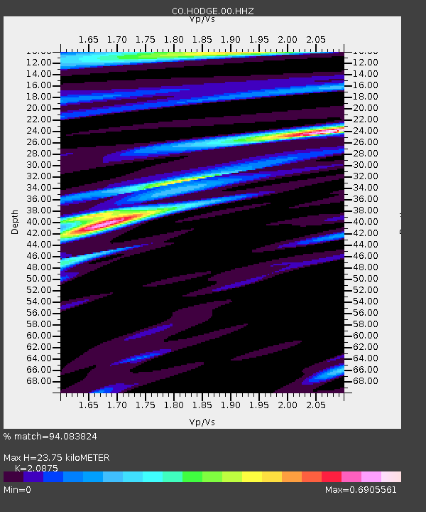
| Estimated Moho Depth: |
23.75 km |
| Estimated Crust Vp/Vs: |
2.09 |
| Assumed Crust Vp: |
6.35 km/s |
| Estimated Crust Vs: |
3.042 km/s |
| Estimated Crust Poisson's Ratio: |
0.35 |
|
| Radial Match: |
94.083824 % |
| Radial Bump: |
390 |
| Transverse Match: |
84.2402 % |
| Transverse Bump: |
400 |
| SOD ConfigId: |
512894 |
| Insert Time: |
2013-09-13 11:10:04.756 +0000 |
| GWidth: |
2.5 |
| Max Bumps: |
400 |
| Tol: |
0.001 |
|

Signal To Noise
| Channel | StoN | STA | LTA |
| CO:HODGE:00:HHZ:20130419T03:17:53.090002Z | 41.59689 | 4.842236E-6 | 1.16408614E-7 |
| CO:HODGE:00:HHN:20130419T03:17:53.090002Z | 7.8631163 | 1.3135514E-6 | 1.6705226E-7 |
| CO:HODGE:00:HHE:20130419T03:17:53.090002Z | 5.2670803 | 7.791383E-7 | 1.4792603E-7 |
| Arrivals |
| Ps | 4.1 SECOND |
| PpPs | 11 SECOND |
| PsPs/PpSs | 15 SECOND |


