You are here: Home > Network List > 7A - Mid-Atlantic Geophysical Integrative Collaboration Stations List
> Station WLFT Gordonsville, Virginia USA > Earthquake Result Viewer
WLFT Gordonsville, Virginia USA - Earthquake Result Viewer
| Earthquake location: |
Kuril Islands |
| Earthquake latitude/longitude: |
44.6/148.7 |
| Earthquake time(UTC): |
2014/07/20 (201) 18:32:47 GMT |
| Earthquake Depth: |
61 km |
| Earthquake Magnitude: |
6.6 MB |
| Earthquake Catalog/Contributor: |
NEIC PDE/NEIC COMCAT |
|
| Network: |
7A Mid-Atlantic Geophysical Integrative Collaboration |
| Station: |
WLFT Gordonsville, Virginia USA |
| Lat/Lon: |
38.17 N/78.14 W |
| Elevation: |
110 m |
|
| Distance: |
87.4 deg |
| Az: |
35.162 deg |
| Baz: |
328.554 deg |
| Ray Param: |
0.043272793 |
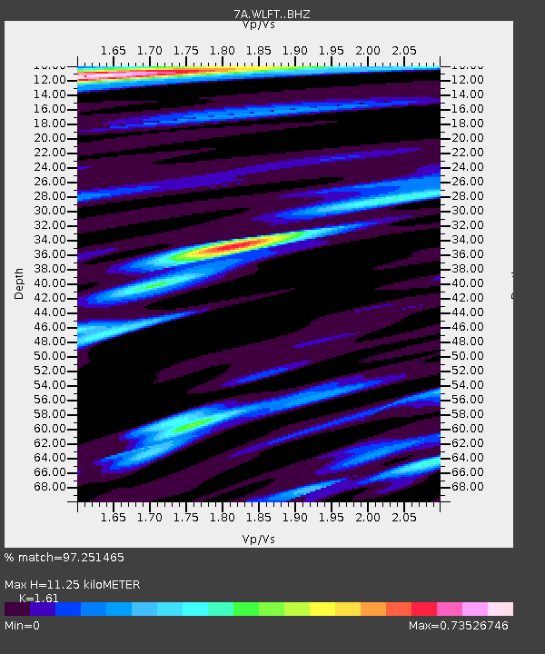
| Estimated Moho Depth: |
11.25 km |
| Estimated Crust Vp/Vs: |
1.61 |
| Assumed Crust Vp: |
6.159 km/s |
| Estimated Crust Vs: |
3.825 km/s |
| Estimated Crust Poisson's Ratio: |
0.19 |
|
| Radial Match: |
97.251465 % |
| Radial Bump: |
400 |
| Transverse Match: |
92.94705 % |
| Transverse Bump: |
400 |
| SOD ConfigId: |
3390531 |
| Insert Time: |
2019-04-12 23:30:36.948 +0000 |
| GWidth: |
2.5 |
| Max Bumps: |
400 |
| Tol: |
0.001 |
|

Signal To Noise
| Channel | StoN | STA | LTA |
| 7A:WLFT: :BHZ:20140720T18:44:56.824995Z | 96.39844 | 5.420017E-6 | 5.6225154E-8 |
| 7A:WLFT: :BHN:20140720T18:44:56.824995Z | 22.169827 | 1.4782016E-6 | 6.6676286E-8 |
| 7A:WLFT: :BHE:20140720T18:44:56.824995Z | 9.283025 | 5.032448E-7 | 5.4211295E-8 |
| Arrivals |
| Ps | 1.1 SECOND |
| PpPs | 4.7 SECOND |
| PsPs/PpSs | 5.8 SECOND |


