You are here: Home > Network List > EI - Irish National Seismic Network (INSN) Stations List
> Station IGLA GLENGOWLA, CO GALWAY, IRELAND > Earthquake Result Viewer
IGLA GLENGOWLA, CO GALWAY, IRELAND - Earthquake Result Viewer
| Earthquake location: |
Kuril Islands |
| Earthquake latitude/longitude: |
46.2/150.8 |
| Earthquake time(UTC): |
2013/04/19 (109) 03:05:52 GMT |
| Earthquake Depth: |
110 km |
| Earthquake Magnitude: |
7.2 MW, 7.1 MB, 7.2 MW |
| Earthquake Catalog/Contributor: |
NEIC PDE/NEIC PDE-W |
|
| Network: |
EI Irish National Seismic Network (INSN) |
| Station: |
IGLA GLENGOWLA, CO GALWAY, IRELAND |
| Lat/Lon: |
53.42 N/9.38 W |
| Elevation: |
31 m |
|
| Distance: |
79.3 deg |
| Az: |
348.071 deg |
| Baz: |
13.873 deg |
| Ray Param: |
0.04880249 |
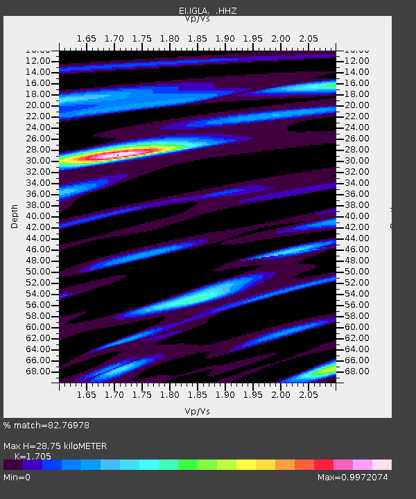
| Estimated Moho Depth: |
28.75 km |
| Estimated Crust Vp/Vs: |
1.71 |
| Assumed Crust Vp: |
6.276 km/s |
| Estimated Crust Vs: |
3.681 km/s |
| Estimated Crust Poisson's Ratio: |
0.24 |
|
| Radial Match: |
82.76978 % |
| Radial Bump: |
365 |
| Transverse Match: |
62.487602 % |
| Transverse Bump: |
400 |
| SOD ConfigId: |
512894 |
| Insert Time: |
2013-09-13 11:11:13.456 +0000 |
| GWidth: |
2.5 |
| Max Bumps: |
400 |
| Tol: |
0.001 |
|

Signal To Noise
| Channel | StoN | STA | LTA |
| EI:IGLA: :HHZ:20130419T03:17:15.040015Z | 4.323391 | 6.6843468E-6 | 1.5460889E-6 |
| EI:IGLA: :HHN:20130419T03:17:15.040015Z | 3.1470623 | 2.14625E-6 | 6.819852E-7 |
| EI:IGLA: :HHE:20130419T03:17:15.040015Z | 2.446817 | 1.3813604E-6 | 5.645541E-7 |
| Arrivals |
| Ps | 3.3 SECOND |
| PpPs | 12 SECOND |
| PsPs/PpSs | 15 SECOND |


