You are here: Home > Network List > G - GEOSCOPE Stations List
> Station NOUC Port Laguerre, New Caledonia > Earthquake Result Viewer
NOUC Port Laguerre, New Caledonia - Earthquake Result Viewer
| Earthquake location: |
Kuril Islands |
| Earthquake latitude/longitude: |
46.2/150.8 |
| Earthquake time(UTC): |
2013/04/19 (109) 03:05:52 GMT |
| Earthquake Depth: |
110 km |
| Earthquake Magnitude: |
7.2 MW, 7.1 MB, 7.2 MW |
| Earthquake Catalog/Contributor: |
NEIC PDE/NEIC PDE-W |
|
| Network: |
G GEOSCOPE |
| Station: |
NOUC Port Laguerre, New Caledonia |
| Lat/Lon: |
22.10 S/166.30 E |
| Elevation: |
112 m |
|
| Distance: |
69.4 deg |
| Az: |
164.636 deg |
| Baz: |
348.559 deg |
| Ray Param: |
0.055362232 |
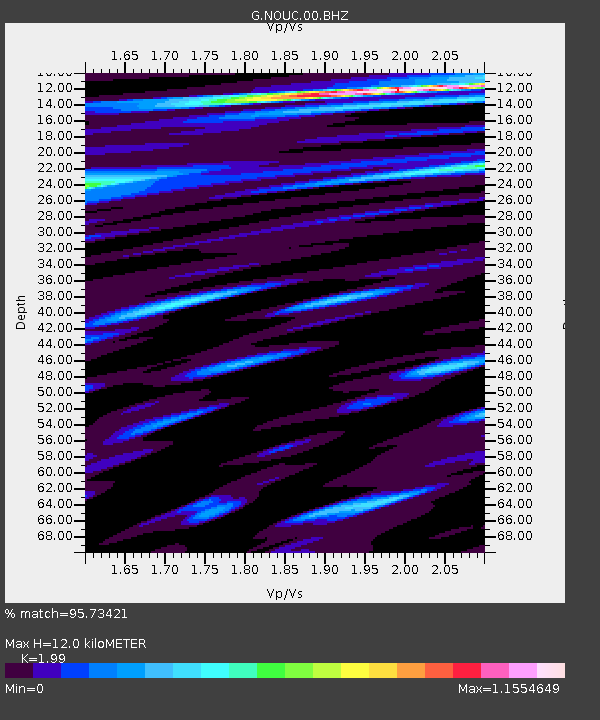
| Estimated Moho Depth: |
12.0 km |
| Estimated Crust Vp/Vs: |
1.99 |
| Assumed Crust Vp: |
5.14 km/s |
| Estimated Crust Vs: |
2.583 km/s |
| Estimated Crust Poisson's Ratio: |
0.33 |
|
| Radial Match: |
95.73421 % |
| Radial Bump: |
400 |
| Transverse Match: |
95.03735 % |
| Transverse Bump: |
400 |
| SOD ConfigId: |
512894 |
| Insert Time: |
2013-09-13 11:11:42.308 +0000 |
| GWidth: |
2.5 |
| Max Bumps: |
400 |
| Tol: |
0.001 |
|

Signal To Noise
| Channel | StoN | STA | LTA |
| G:NOUC:00:BHZ:20130419T03:16:18.100012Z | 4.1083636 | 1.5418548E-6 | 3.7529657E-7 |
| G:NOUC:00:BHN:20130419T03:16:18.100012Z | 0.9091251 | 4.0780222E-7 | 4.4856554E-7 |
| G:NOUC:00:BHE:20130419T03:16:18.100012Z | 0.85793394 | 2.4211275E-7 | 2.8220444E-7 |
| Arrivals |
| Ps | 2.4 SECOND |
| PpPs | 6.8 SECOND |
| PsPs/PpSs | 9.2 SECOND |


