You are here: Home > Network List > G - GEOSCOPE Stations List
> Station SANVU Espiritu Santo, Vanuatu > Earthquake Result Viewer
SANVU Espiritu Santo, Vanuatu - Earthquake Result Viewer
| Earthquake location: |
Kuril Islands |
| Earthquake latitude/longitude: |
46.2/150.8 |
| Earthquake time(UTC): |
2013/04/19 (109) 03:05:52 GMT |
| Earthquake Depth: |
110 km |
| Earthquake Magnitude: |
7.2 MW, 7.1 MB, 7.2 MW |
| Earthquake Catalog/Contributor: |
NEIC PDE/NEIC PDE-W |
|
| Network: |
G GEOSCOPE |
| Station: |
SANVU Espiritu Santo, Vanuatu |
| Lat/Lon: |
15.45 S/167.20 E |
| Elevation: |
56 m |
|
| Distance: |
63.1 deg |
| Az: |
162.214 deg |
| Baz: |
347.295 deg |
| Ray Param: |
0.059464566 |
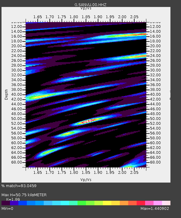
| Estimated Moho Depth: |
50.75 km |
| Estimated Crust Vp/Vs: |
1.86 |
| Assumed Crust Vp: |
4.802 km/s |
| Estimated Crust Vs: |
2.582 km/s |
| Estimated Crust Poisson's Ratio: |
0.30 |
|
| Radial Match: |
93.0459 % |
| Radial Bump: |
400 |
| Transverse Match: |
86.59264 % |
| Transverse Bump: |
400 |
| SOD ConfigId: |
512894 |
| Insert Time: |
2013-09-13 11:11:49.566 +0000 |
| GWidth: |
2.5 |
| Max Bumps: |
400 |
| Tol: |
0.001 |
|

Signal To Noise
| Channel | StoN | STA | LTA |
| G:SANVU:00:HHZ:20130419T03:15:38.038977Z | 12.190847 | 6.372166E-6 | 5.227008E-7 |
| G:SANVU:00:HHN:20130419T03:15:38.038977Z | 7.598542 | 2.5347256E-6 | 3.3358052E-7 |
| G:SANVU:00:HHE:20130419T03:15:38.038977Z | 1.0210627 | 8.3347624E-7 | 8.162831E-7 |
| Arrivals |
| Ps | 9.3 SECOND |
| PpPs | 30 SECOND |
| PsPs/PpSs | 39 SECOND |


