You are here: Home > Network List > GE - GEOFON Stations List
> Station DAMY GEOFON Station Dhamar, Yemen > Earthquake Result Viewer
DAMY GEOFON Station Dhamar, Yemen - Earthquake Result Viewer
| Earthquake location: |
Kuril Islands |
| Earthquake latitude/longitude: |
46.2/150.8 |
| Earthquake time(UTC): |
2013/04/19 (109) 03:05:52 GMT |
| Earthquake Depth: |
110 km |
| Earthquake Magnitude: |
7.2 MW, 7.1 MB, 7.2 MW |
| Earthquake Catalog/Contributor: |
NEIC PDE/NEIC PDE-W |
|
| Network: |
GE GEOFON |
| Station: |
DAMY GEOFON Station Dhamar, Yemen |
| Lat/Lon: |
14.57 N/44.39 E |
| Elevation: |
2488 m |
|
| Distance: |
90.6 deg |
| Az: |
291.735 deg |
| Baz: |
41.766 deg |
| Ray Param: |
0.04164262 |
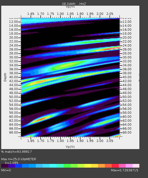
| Estimated Moho Depth: |
25.0 km |
| Estimated Crust Vp/Vs: |
2.10 |
| Assumed Crust Vp: |
6.65 km/s |
| Estimated Crust Vs: |
3.174 km/s |
| Estimated Crust Poisson's Ratio: |
0.35 |
|
| Radial Match: |
93.99917 % |
| Radial Bump: |
400 |
| Transverse Match: |
72.02844 % |
| Transverse Bump: |
400 |
| SOD ConfigId: |
512894 |
| Insert Time: |
2013-09-13 11:12:18.920 +0000 |
| GWidth: |
2.5 |
| Max Bumps: |
400 |
| Tol: |
0.001 |
|

Signal To Noise
| Channel | StoN | STA | LTA |
| GE:DAMY: :HHZ:20130419T03:18:11.147986Z | 12.526056 | 9.769426E-7 | 7.799283E-8 |
| GE:DAMY: :HHN:20130419T03:18:11.147986Z | 2.6457803 | 2.6769038E-7 | 1.0117634E-7 |
| GE:DAMY: :HHE:20130419T03:18:11.147986Z | 2.1908033 | 1.629037E-7 | 7.435798E-8 |
| Arrivals |
| Ps | 4.2 SECOND |
| PpPs | 11 SECOND |
| PsPs/PpSs | 16 SECOND |


