You are here: Home > Network List > GO - National Seismic Network of Georgia Stations List
> Station ONI Oni, Georgia > Earthquake Result Viewer
ONI Oni, Georgia - Earthquake Result Viewer

| Earthquake location: |
Kuril Islands |
| Earthquake latitude/longitude: |
46.2/150.8 |
| Earthquake time(UTC): |
2013/04/19 (109) 03:05:52 GMT |
| Earthquake Depth: |
110 km |
| Earthquake Magnitude: |
7.2 MW, 7.1 MB, 7.2 MW |
| Earthquake Catalog/Contributor: |
NEIC PDE/NEIC PDE-W |
|
| Network: |
GO National Seismic Network of Georgia |
| Station: |
ONI Oni, Georgia |
| Lat/Lon: |
42.59 N/43.45 E |
| Elevation: |
0.0 m |
|
| Distance: |
70.6 deg |
| Az: |
311.63 deg |
| Baz: |
44.648 deg |
| Ray Param: |
0.05461057 |
| Estimated Moho Depth: |
13.25 km |
| Estimated Crust Vp/Vs: |
1.60 |
| Assumed Crust Vp: |
6.247 km/s |
| Estimated Crust Vs: |
3.904 km/s |
| Estimated Crust Poisson's Ratio: |
0.18 |
|
| Radial Match: |
91.74882 % |
| Radial Bump: |
400 |
| Transverse Match: |
87.051315 % |
| Transverse Bump: |
400 |
| SOD ConfigId: |
512894 |
| Insert Time: |
2013-09-13 11:13:12.889 +0000 |
| GWidth: |
2.5 |
| Max Bumps: |
400 |
| Tol: |
0.001 |
|
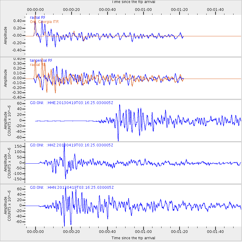
Signal To Noise
| Channel | StoN | STA | LTA |
| GO:ONI: :HHZ:20130419T03:16:25.030005Z | 22.395426 | 4.4078147E-6 | 1.9681764E-7 |
| GO:ONI: :HHN:20130419T03:16:25.030005Z | 7.156761 | 1.0885456E-6 | 1.521003E-7 |
| GO:ONI: :HHE:20130419T03:16:25.030005Z | 9.230732 | 8.535302E-7 | 9.2466145E-8 |
| Arrivals |
| Ps | 1.3 SECOND |
| PpPs | 5.3 SECOND |
| PsPs/PpSs | 6.6 SECOND |


