You are here: Home > Network List > GR - German Regional Seismic Network or Graefenberg Array Stations List
> Station GRA1 GRAEFENBERG_ARRAY_STATION_HAIDHOF,_BAVARIA,_FRG > Earthquake Result Viewer
GRA1 GRAEFENBERG_ARRAY_STATION_HAIDHOF,_BAVARIA,_FRG - Earthquake Result Viewer
| Earthquake location: |
Kuril Islands |
| Earthquake latitude/longitude: |
46.2/150.8 |
| Earthquake time(UTC): |
2013/04/19 (109) 03:05:52 GMT |
| Earthquake Depth: |
110 km |
| Earthquake Magnitude: |
7.2 MW, 7.1 MB, 7.2 MW |
| Earthquake Catalog/Contributor: |
NEIC PDE/NEIC PDE-W |
|
| Network: |
GR German Regional Seismic Network or Graefenberg Array |
| Station: |
GRA1 GRAEFENBERG_ARRAY_STATION_HAIDHOF,_BAVARIA,_FRG |
| Lat/Lon: |
49.69 N/11.22 E |
| Elevation: |
500 m |
|
| Distance: |
78.2 deg |
| Az: |
334.517 deg |
| Baz: |
27.386 deg |
| Ray Param: |
0.04953201 |
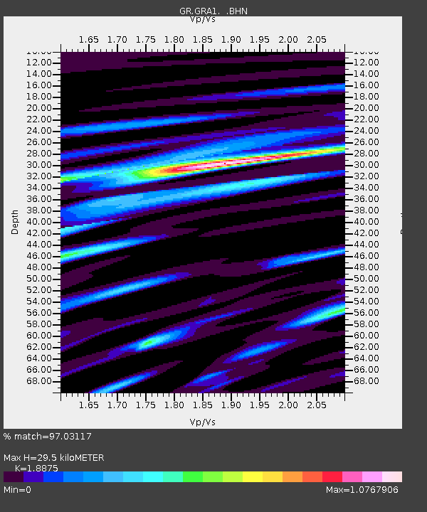
| Estimated Moho Depth: |
29.5 km |
| Estimated Crust Vp/Vs: |
1.89 |
| Assumed Crust Vp: |
6.182 km/s |
| Estimated Crust Vs: |
3.275 km/s |
| Estimated Crust Poisson's Ratio: |
0.30 |
|
| Radial Match: |
97.03117 % |
| Radial Bump: |
313 |
| Transverse Match: |
93.94874 % |
| Transverse Bump: |
315 |
| SOD ConfigId: |
512894 |
| Insert Time: |
2013-09-13 11:13:20.518 +0000 |
| GWidth: |
2.5 |
| Max Bumps: |
400 |
| Tol: |
0.001 |
|

Signal To Noise
| Channel | StoN | STA | LTA |
| GR:GRA1: :BHZ:20130419T03:17:09.183997Z | 20.718374 | 6.978468E-6 | 3.3682508E-7 |
| GR:GRA1: :BHN:20130419T03:17:09.183997Z | 5.298533 | 1.5747707E-6 | 2.9720883E-7 |
| GR:GRA1: :BHE:20130419T03:17:09.183997Z | 3.8924797 | 1.031849E-6 | 2.6508786E-7 |
| Arrivals |
| Ps | 4.3 SECOND |
| PpPs | 13 SECOND |
| PsPs/PpSs | 18 SECOND |


