You are here: Home > Network List > KR - Kyrgyz Digital Network Stations List
> Station ARLS Aral, Kyrgyzstan > Earthquake Result Viewer
ARLS Aral, Kyrgyzstan - Earthquake Result Viewer
| Earthquake location: |
Kuril Islands |
| Earthquake latitude/longitude: |
44.6/148.7 |
| Earthquake time(UTC): |
2014/07/20 (201) 18:32:47 GMT |
| Earthquake Depth: |
61 km |
| Earthquake Magnitude: |
6.6 MB |
| Earthquake Catalog/Contributor: |
NEIC PDE/NEIC COMCAT |
|
| Network: |
KR Kyrgyz Digital Network |
| Station: |
ARLS Aral, Kyrgyzstan |
| Lat/Lon: |
41.87 N/74.33 E |
| Elevation: |
1526 m |
|
| Distance: |
52.5 deg |
| Az: |
294.918 deg |
| Baz: |
60.119 deg |
| Ray Param: |
0.0665671 |
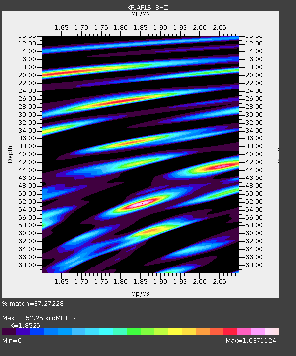
| Estimated Moho Depth: |
52.25 km |
| Estimated Crust Vp/Vs: |
1.85 |
| Assumed Crust Vp: |
6.491 km/s |
| Estimated Crust Vs: |
3.504 km/s |
| Estimated Crust Poisson's Ratio: |
0.29 |
|
| Radial Match: |
87.27228 % |
| Radial Bump: |
400 |
| Transverse Match: |
86.81851 % |
| Transverse Bump: |
400 |
| SOD ConfigId: |
3390531 |
| Insert Time: |
2019-04-12 23:33:17.555 +0000 |
| GWidth: |
2.5 |
| Max Bumps: |
400 |
| Tol: |
0.001 |
|

Signal To Noise
| Channel | StoN | STA | LTA |
| KR:ARLS: :BHZ:20140720T18:41:24.249983Z | 154.64743 | 7.5182043E-6 | 4.8615124E-8 |
| KR:ARLS: :BHN:20140720T18:41:24.249983Z | 54.210407 | 2.1269852E-6 | 3.9235736E-8 |
| KR:ARLS: :BHE:20140720T18:41:24.249983Z | 178.03354 | 3.4192508E-6 | 1.9205656E-8 |
| Arrivals |
| Ps | 7.2 SECOND |
| PpPs | 22 SECOND |
| PsPs/PpSs | 29 SECOND |


