You are here: Home > Network List > NX - Nanometrics Research Network Stations List
> Station STN08 Seismic station 08 > Earthquake Result Viewer
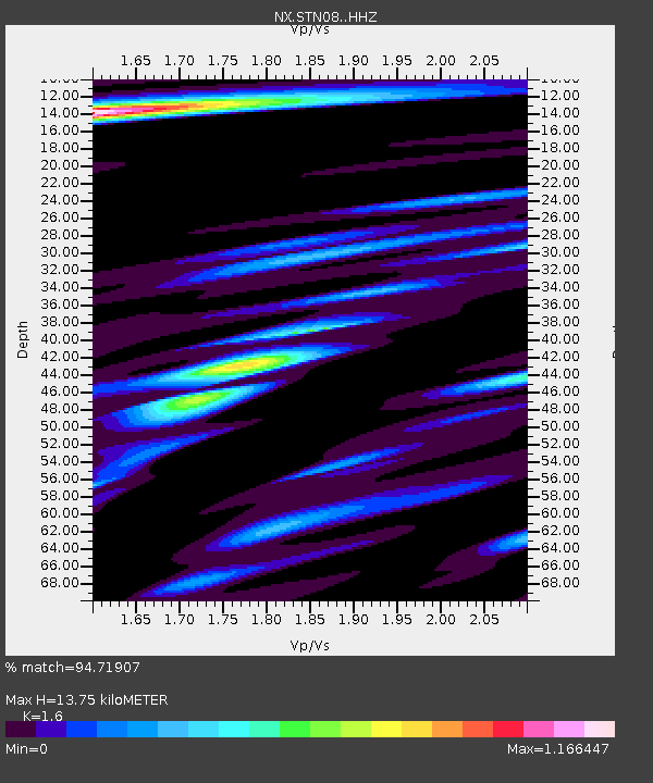
STN08 Seismic station 08 - Earthquake Result Viewer
| Earthquake location: |
Kuril Islands |
| Earthquake latitude/longitude: |
44.6/148.7 |
| Earthquake time(UTC): |
2014/07/20 (201) 18:32:47 GMT |
| Earthquake Depth: |
61 km |
| Earthquake Magnitude: |
6.6 MB |
| Earthquake Catalog/Contributor: |
NEIC PDE/NEIC COMCAT |
|
| Network: |
NX Nanometrics Research Network |
| Station: |
STN08 Seismic station 08 |
| Lat/Lon: |
36.18 N/97.49 W |
| Elevation: |
359 m |
|
| Distance: |
79.7 deg |
| Az: |
48.803 deg |
| Baz: |
318.386 deg |
| Ray Param: |
0.048651453 |
| Estimated Moho Depth: |
13.75 km |
| Estimated Crust Vp/Vs: |
1.60 |
| Assumed Crust Vp: |
6.483 km/s |
| Estimated Crust Vs: |
4.052 km/s |
| Estimated Crust Poisson's Ratio: |
0.18 |
|
| Radial Match: |
94.71907 % |
| Radial Bump: |
379 |
| Transverse Match: |
92.53232 % |
| Transverse Bump: |
364 |
| SOD ConfigId: |
3390531 |
| Insert Time: |
2019-04-12 23:34:04.010 +0000 |
| GWidth: |
2.5 |
| Max Bumps: |
400 |
| Tol: |
0.001 |
|

Signal To Noise
| Channel | StoN | STA | LTA |
| NX:STN08: :HHZ:20140720T18:44:17.780012Z | 48.76929 | 4.2709084E-6 | 8.7573724E-8 |
| NX:STN08: :HH1:20140720T18:44:17.780012Z | 22.44153 | 1.5081291E-6 | 6.720259E-8 |
| NX:STN08: :HH2:20140720T18:44:17.780012Z | 3.5334687 | 2.757512E-7 | 7.8039804E-8 |
| Arrivals |
| Ps | 1.3 SECOND |
| PpPs | 5.3 SECOND |
| PsPs/PpSs | 6.7 SECOND |


