You are here: Home > Network List > IC - New China Digital Seismograph Network Stations List
> Station QIZ Qiongzhong, Hainan Province, China > Earthquake Result Viewer
QIZ Qiongzhong, Hainan Province, China - Earthquake Result Viewer

| Earthquake location: |
Kuril Islands |
| Earthquake latitude/longitude: |
46.2/150.8 |
| Earthquake time(UTC): |
2013/04/19 (109) 03:05:52 GMT |
| Earthquake Depth: |
110 km |
| Earthquake Magnitude: |
7.2 MW, 7.1 MB, 7.2 MW |
| Earthquake Catalog/Contributor: |
NEIC PDE/NEIC PDE-W |
|
| Network: |
IC New China Digital Seismograph Network |
| Station: |
QIZ Qiongzhong, Hainan Province, China |
| Lat/Lon: |
19.03 N/109.84 E |
| Elevation: |
240 m |
|
| Distance: |
43.2 deg |
| Az: |
244.987 deg |
| Baz: |
41.688 deg |
| Ray Param: |
0.07233232 |
| Estimated Moho Depth: |
34.75 km |
| Estimated Crust Vp/Vs: |
1.68 |
| Assumed Crust Vp: |
6.182 km/s |
| Estimated Crust Vs: |
3.691 km/s |
| Estimated Crust Poisson's Ratio: |
0.22 |
|
| Radial Match: |
97.44976 % |
| Radial Bump: |
297 |
| Transverse Match: |
83.978004 % |
| Transverse Bump: |
400 |
| SOD ConfigId: |
512894 |
| Insert Time: |
2013-09-13 11:15:07.739 +0000 |
| GWidth: |
2.5 |
| Max Bumps: |
400 |
| Tol: |
0.001 |
|
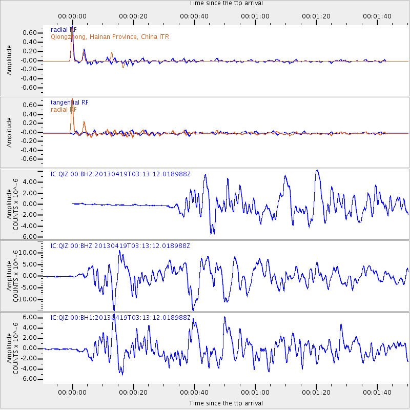
Signal To Noise
| Channel | StoN | STA | LTA |
| IC:QIZ:00:BHZ:20130419T03:13:12.018988Z | 8.066462 | 6.297965E-7 | 7.807593E-8 |
| IC:QIZ:00:BH1:20130419T03:13:12.018988Z | 5.301448 | 2.617642E-7 | 4.9375984E-8 |
| IC:QIZ:00:BH2:20130419T03:13:12.018988Z | 3.3837242 | 3.3145773E-7 | 9.795649E-8 |
| Arrivals |
| Ps | 4.0 SECOND |
| PpPs | 14 SECOND |
| PsPs/PpSs | 18 SECOND |


