You are here: Home > Network List > II - Global Seismograph Network (GSN - IRIS/IDA) Stations List
> Station ARU Arti, Russia > Earthquake Result Viewer
ARU Arti, Russia - Earthquake Result Viewer
| Earthquake location: |
Kuril Islands |
| Earthquake latitude/longitude: |
46.2/150.8 |
| Earthquake time(UTC): |
2013/04/19 (109) 03:05:52 GMT |
| Earthquake Depth: |
110 km |
| Earthquake Magnitude: |
7.2 MW, 7.1 MB, 7.2 MW |
| Earthquake Catalog/Contributor: |
NEIC PDE/NEIC PDE-W |
|
| Network: |
II Global Seismograph Network (GSN - IRIS/IDA) |
| Station: |
ARU Arti, Russia |
| Lat/Lon: |
56.43 N/58.56 E |
| Elevation: |
260 m |
|
| Distance: |
54.3 deg |
| Az: |
316.881 deg |
| Baz: |
58.674 deg |
| Ray Param: |
0.06519385 |
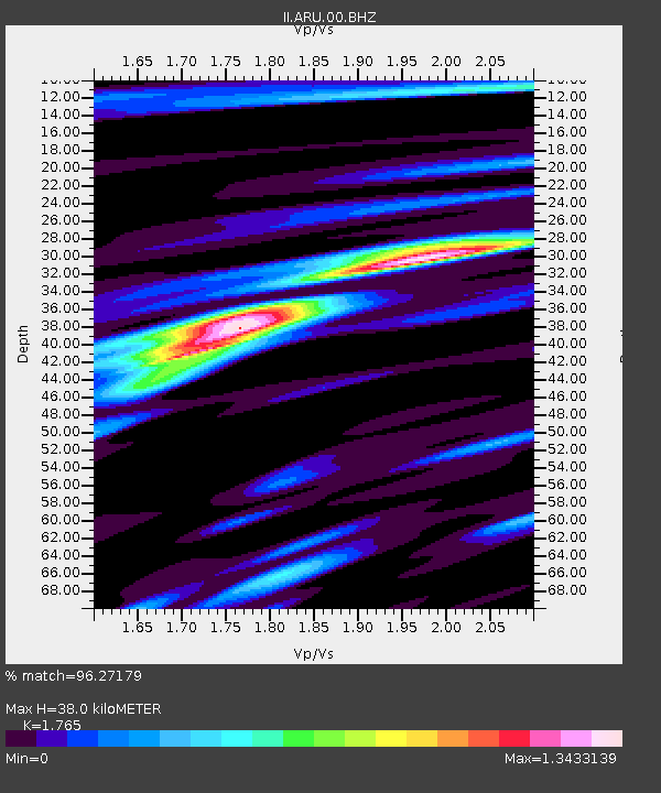
| Estimated Moho Depth: |
38.0 km |
| Estimated Crust Vp/Vs: |
1.76 |
| Assumed Crust Vp: |
6.159 km/s |
| Estimated Crust Vs: |
3.489 km/s |
| Estimated Crust Poisson's Ratio: |
0.26 |
|
| Radial Match: |
96.27179 % |
| Radial Bump: |
400 |
| Transverse Match: |
88.99147 % |
| Transverse Bump: |
400 |
| SOD ConfigId: |
512894 |
| Insert Time: |
2013-09-13 11:15:18.596 +0000 |
| GWidth: |
2.5 |
| Max Bumps: |
400 |
| Tol: |
0.001 |
|

Signal To Noise
| Channel | StoN | STA | LTA |
| II:ARU:00:BHZ:20130419T03:14:37.019019Z | 14.465908 | 5.5439787E-6 | 3.832444E-7 |
| II:ARU:00:BH1:20130419T03:14:37.019019Z | 4.423302 | 1.5192632E-6 | 3.434681E-7 |
| II:ARU:00:BH2:20130419T03:14:37.019019Z | 7.468943 | 2.2314198E-6 | 2.987598E-7 |
| Arrivals |
| Ps | 5.0 SECOND |
| PpPs | 16 SECOND |
| PsPs/PpSs | 21 SECOND |


