You are here: Home > Network List > IM - International Miscellaneous Stations Stations List
> Station TX31 TXAR Array, Lajitas, TX, USA > Earthquake Result Viewer
TX31 TXAR Array, Lajitas, TX, USA - Earthquake Result Viewer
| Earthquake location: |
Kuril Islands |
| Earthquake latitude/longitude: |
46.2/150.8 |
| Earthquake time(UTC): |
2013/04/19 (109) 03:05:52 GMT |
| Earthquake Depth: |
110 km |
| Earthquake Magnitude: |
7.2 MW, 7.1 MB, 7.2 MW |
| Earthquake Catalog/Contributor: |
NEIC PDE/NEIC PDE-W |
|
| Network: |
IM International Miscellaneous Stations |
| Station: |
TX31 TXAR Array, Lajitas, TX, USA |
| Lat/Lon: |
29.33 N/103.67 W |
| Elevation: |
1025 m |
|
| Distance: |
79.1 deg |
| Az: |
58.933 deg |
| Baz: |
317.071 deg |
| Ray Param: |
0.04890886 |
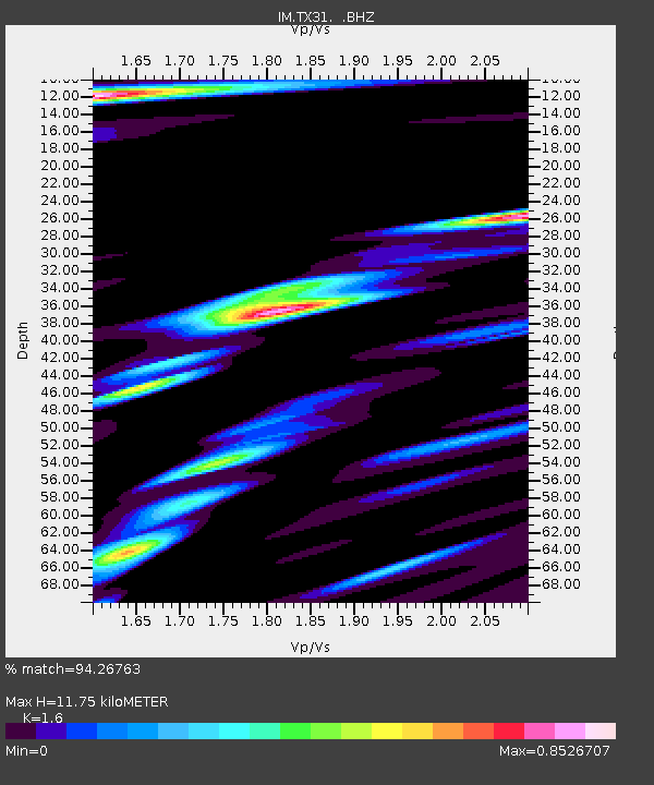
| Estimated Moho Depth: |
11.75 km |
| Estimated Crust Vp/Vs: |
1.60 |
| Assumed Crust Vp: |
6.419 km/s |
| Estimated Crust Vs: |
4.012 km/s |
| Estimated Crust Poisson's Ratio: |
0.18 |
|
| Radial Match: |
94.26763 % |
| Radial Bump: |
400 |
| Transverse Match: |
91.43516 % |
| Transverse Bump: |
400 |
| SOD ConfigId: |
512894 |
| Insert Time: |
2013-09-13 11:16:12.470 +0000 |
| GWidth: |
2.5 |
| Max Bumps: |
400 |
| Tol: |
0.001 |
|

Signal To Noise
| Channel | StoN | STA | LTA |
| IM:TX31: :BHZ:20130419T03:17:14.199988Z | 70.86074 | 4.2136986E-7 | 5.9464496E-9 |
| IM:TX31: :BHN:20130419T03:17:14.199988Z | 8.981343 | 5.7044122E-8 | 6.3514016E-9 |
| IM:TX31: :BHE:20130419T03:17:14.199988Z | 37.463078 | 1.3304964E-7 | 3.551487E-9 |
| Arrivals |
| Ps | 1.1 SECOND |
| PpPs | 4.6 SECOND |
| PsPs/PpSs | 5.7 SECOND |


