You are here: Home > Network List > NX - Nanometrics Research Network Stations List
> Station STN21 Seismic station 21 > Earthquake Result Viewer
STN21 Seismic station 21 - Earthquake Result Viewer
| Earthquake location: |
Kuril Islands |
| Earthquake latitude/longitude: |
44.6/148.7 |
| Earthquake time(UTC): |
2014/07/20 (201) 18:32:47 GMT |
| Earthquake Depth: |
61 km |
| Earthquake Magnitude: |
6.6 MB |
| Earthquake Catalog/Contributor: |
NEIC PDE/NEIC COMCAT |
|
| Network: |
NX Nanometrics Research Network |
| Station: |
STN21 Seismic station 21 |
| Lat/Lon: |
36.75 N/97.56 W |
| Elevation: |
333 m |
|
| Distance: |
79.3 deg |
| Az: |
48.459 deg |
| Baz: |
318.282 deg |
| Ray Param: |
0.04896866 |
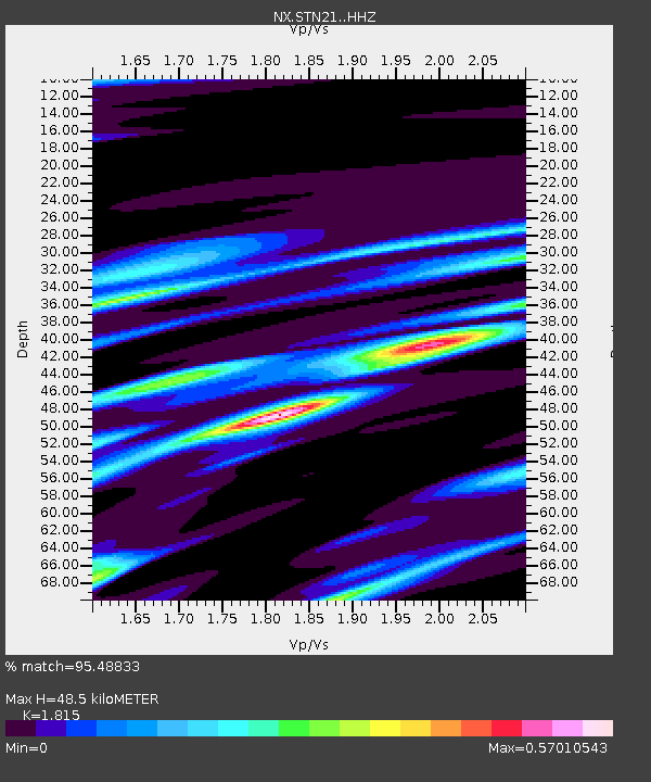
| Estimated Moho Depth: |
48.5 km |
| Estimated Crust Vp/Vs: |
1.82 |
| Assumed Crust Vp: |
6.483 km/s |
| Estimated Crust Vs: |
3.572 km/s |
| Estimated Crust Poisson's Ratio: |
0.28 |
|
| Radial Match: |
95.48833 % |
| Radial Bump: |
309 |
| Transverse Match: |
79.31262 % |
| Transverse Bump: |
400 |
| SOD ConfigId: |
3390531 |
| Insert Time: |
2019-04-12 23:34:17.069 +0000 |
| GWidth: |
2.5 |
| Max Bumps: |
400 |
| Tol: |
0.001 |
|

Signal To Noise
| Channel | StoN | STA | LTA |
| NX:STN21: :HHZ:20140720T18:44:15.270002Z | 47.810272 | 3.8317503E-6 | 8.0144915E-8 |
| NX:STN21: :HH1:20140720T18:44:15.270002Z | 20.123121 | 1.5140664E-6 | 7.524014E-8 |
| NX:STN21: :HH2:20140720T18:44:15.270002Z | 11.880655 | 9.941986E-7 | 8.368214E-8 |
| Arrivals |
| Ps | 6.3 SECOND |
| PpPs | 20 SECOND |
| PsPs/PpSs | 27 SECOND |


