You are here: Home > Network List > NX - Nanometrics Research Network Stations List
> Station STN33 Seismic station 28 > Earthquake Result Viewer
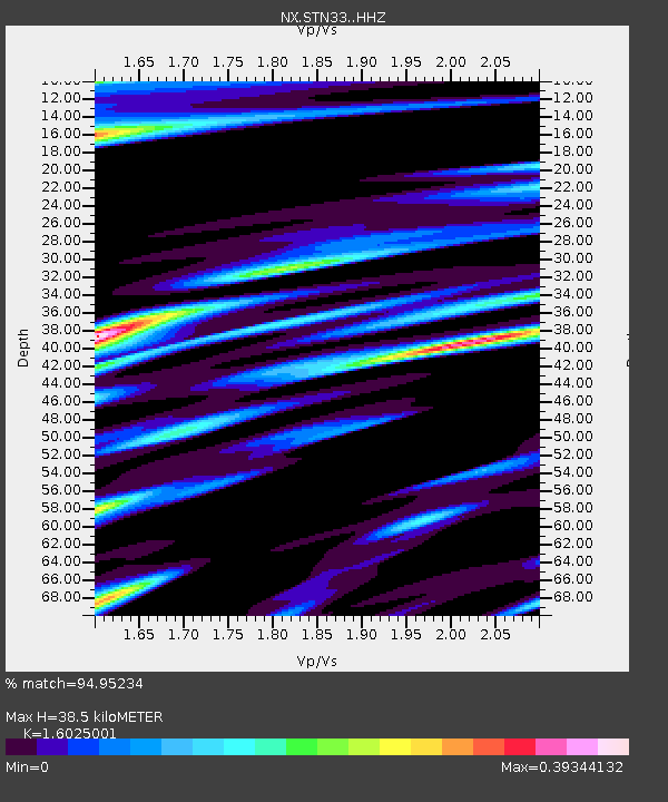
STN33 Seismic station 28 - Earthquake Result Viewer
| Earthquake location: |
Kuril Islands |
| Earthquake latitude/longitude: |
44.6/148.7 |
| Earthquake time(UTC): |
2014/07/20 (201) 18:32:47 GMT |
| Earthquake Depth: |
61 km |
| Earthquake Magnitude: |
6.6 MB |
| Earthquake Catalog/Contributor: |
NEIC PDE/NEIC COMCAT |
|
| Network: |
NX Nanometrics Research Network |
| Station: |
STN33 Seismic station 28 |
| Lat/Lon: |
35.66 N/96.72 W |
| Elevation: |
272 m |
|
| Distance: |
80.5 deg |
| Az: |
48.677 deg |
| Baz: |
318.814 deg |
| Ray Param: |
0.048104 |
| Estimated Moho Depth: |
38.5 km |
| Estimated Crust Vp/Vs: |
1.60 |
| Assumed Crust Vp: |
6.426 km/s |
| Estimated Crust Vs: |
4.01 km/s |
| Estimated Crust Poisson's Ratio: |
0.18 |
|
| Radial Match: |
94.95234 % |
| Radial Bump: |
313 |
| Transverse Match: |
90.14282 % |
| Transverse Bump: |
400 |
| SOD ConfigId: |
3390531 |
| Insert Time: |
2019-04-12 23:34:24.850 +0000 |
| GWidth: |
2.5 |
| Max Bumps: |
400 |
| Tol: |
0.001 |
|

Signal To Noise
| Channel | StoN | STA | LTA |
| NX:STN33: :HHZ:20140720T18:44:22.10002Z | 50.7192 | 3.4140567E-6 | 6.7312904E-8 |
| NX:STN33: :HH1:20140720T18:44:22.10002Z | 9.704329 | 6.8636194E-7 | 7.07274E-8 |
| NX:STN33: :HH2:20140720T18:44:22.10002Z | 12.662649 | 8.642093E-7 | 6.8248696E-8 |
| Arrivals |
| Ps | 3.7 SECOND |
| PpPs | 15 SECOND |
| PsPs/PpSs | 19 SECOND |


