You are here: Home > Network List > IU - Global Seismograph Network (GSN - IRIS/USGS) Stations List
> Station HNR Honiara, Solomon Islands > Earthquake Result Viewer
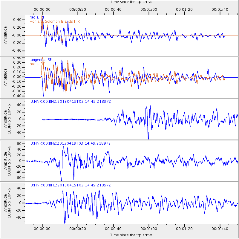
HNR Honiara, Solomon Islands - Earthquake Result Viewer
*The percent match for this event was below the threshold and hence no stack was calculated.
| Earthquake location: |
Kuril Islands |
| Earthquake latitude/longitude: |
46.2/150.8 |
| Earthquake time(UTC): |
2013/04/19 (109) 03:05:52 GMT |
| Earthquake Depth: |
110 km |
| Earthquake Magnitude: |
7.2 MW, 7.1 MB, 7.2 MW |
| Earthquake Catalog/Contributor: |
NEIC PDE/NEIC PDE-W |
|
| Network: |
IU Global Seismograph Network (GSN - IRIS/USGS) |
| Station: |
HNR Honiara, Solomon Islands |
| Lat/Lon: |
9.44 S/159.95 E |
| Elevation: |
100 m |
|
| Distance: |
56.0 deg |
| Az: |
169.081 deg |
| Baz: |
352.34 deg |
| Ray Param: |
$rayparam |
*The percent match for this event was below the threshold and hence was not used in the summary stack. |
|
| Radial Match: |
76.11202 % |
| Radial Bump: |
400 |
| Transverse Match: |
83.096146 % |
| Transverse Bump: |
400 |
| SOD ConfigId: |
512894 |
| Insert Time: |
2013-09-13 11:17:03.887 +0000 |
| GWidth: |
2.5 |
| Max Bumps: |
400 |
| Tol: |
0.001 |
|
Signal To Noise
| Channel | StoN | STA | LTA |
| IU:HNR:00:BHZ:20130419T03:14:49.21897Z | 10.460796 | 5.1907878E-6 | 4.9621343E-7 |
| IU:HNR:00:BH1:20130419T03:14:49.21897Z | 7.4487114 | 2.7332744E-6 | 3.6694595E-7 |
| IU:HNR:00:BH2:20130419T03:14:49.21897Z | 2.7665708 | 1.2677502E-6 | 4.5823887E-7 |
| Arrivals |
| Ps | |
| PpPs | |
| PsPs/PpSs | |


