You are here: Home > Network List > IU - Global Seismograph Network (GSN - IRIS/USGS) Stations List
> Station KEV Kevo, Finland > Earthquake Result Viewer
KEV Kevo, Finland - Earthquake Result Viewer
| Earthquake location: |
Kuril Islands |
| Earthquake latitude/longitude: |
46.2/150.8 |
| Earthquake time(UTC): |
2013/04/19 (109) 03:05:52 GMT |
| Earthquake Depth: |
110 km |
| Earthquake Magnitude: |
7.2 MW, 7.1 MB, 7.2 MW |
| Earthquake Catalog/Contributor: |
NEIC PDE/NEIC PDE-W |
|
| Network: |
IU Global Seismograph Network (GSN - IRIS/USGS) |
| Station: |
KEV Kevo, Finland |
| Lat/Lon: |
69.76 N/27.00 E |
| Elevation: |
100 m |
|
| Distance: |
57.3 deg |
| Az: |
339.892 deg |
| Baz: |
43.296 deg |
| Ray Param: |
0.063258804 |
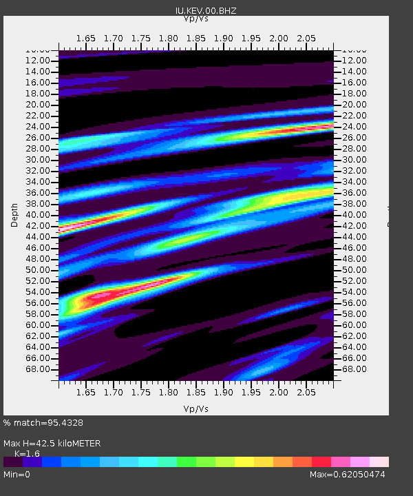
| Estimated Moho Depth: |
42.5 km |
| Estimated Crust Vp/Vs: |
1.60 |
| Assumed Crust Vp: |
6.622 km/s |
| Estimated Crust Vs: |
4.139 km/s |
| Estimated Crust Poisson's Ratio: |
0.18 |
|
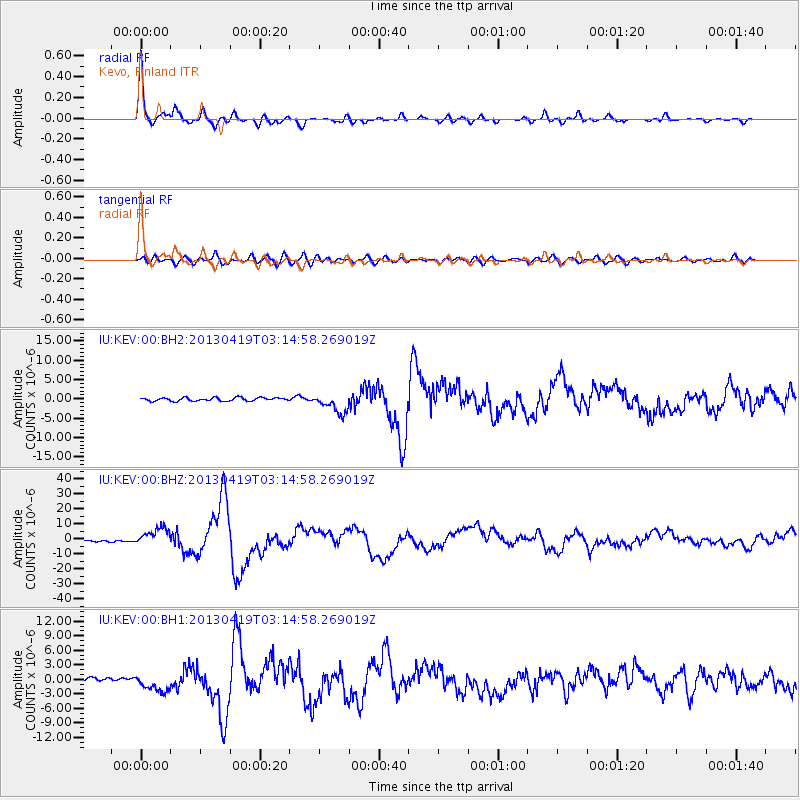
| Radial Match: |
95.4328 % |
| Radial Bump: |
306 |
| Transverse Match: |
79.53487 % |
| Transverse Bump: |
400 |
| SOD ConfigId: |
512894 |
| Insert Time: |
2013-09-13 11:17:15.251 +0000 |
| GWidth: |
2.5 |
| Max Bumps: |
400 |
| Tol: |
0.001 |
|
Signal To Noise
| Channel | StoN | STA | LTA |
| IU:KEV:00:BHZ:20130419T03:14:58.269019Z | 8.499086 | 5.9510817E-6 | 7.002025E-7 |
| IU:KEV:00:BH1:20130419T03:14:58.269019Z | 3.8871627 | 1.8074812E-6 | 4.649873E-7 |
| IU:KEV:00:BH2:20130419T03:14:58.269019Z | 6.0609374 | 2.5836264E-6 | 4.2627505E-7 |
| Arrivals |
| Ps | 4.1 SECOND |
| PpPs | 16 SECOND |
| PsPs/PpSs | 20 SECOND |


