You are here: Home > Network List > IU - Global Seismograph Network (GSN - IRIS/USGS) Stations List
> Station KIEV Kiev, Ukraine > Earthquake Result Viewer
KIEV Kiev, Ukraine - Earthquake Result Viewer
| Earthquake location: |
Kuril Islands |
| Earthquake latitude/longitude: |
46.2/150.8 |
| Earthquake time(UTC): |
2013/04/19 (109) 03:05:52 GMT |
| Earthquake Depth: |
110 km |
| Earthquake Magnitude: |
7.2 MW, 7.1 MB, 7.2 MW |
| Earthquake Catalog/Contributor: |
NEIC PDE/NEIC PDE-W |
|
| Network: |
IU Global Seismograph Network (GSN - IRIS/USGS) |
| Station: |
KIEV Kiev, Ukraine |
| Lat/Lon: |
50.70 N/29.22 E |
| Elevation: |
180 m |
|
| Distance: |
71.1 deg |
| Az: |
325.055 deg |
| Baz: |
38.71 deg |
| Ray Param: |
0.0542916 |
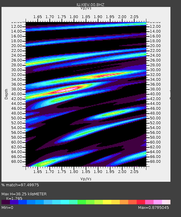
| Estimated Moho Depth: |
38.25 km |
| Estimated Crust Vp/Vs: |
1.76 |
| Assumed Crust Vp: |
6.552 km/s |
| Estimated Crust Vs: |
3.712 km/s |
| Estimated Crust Poisson's Ratio: |
0.26 |
|
| Radial Match: |
97.49975 % |
| Radial Bump: |
330 |
| Transverse Match: |
94.33376 % |
| Transverse Bump: |
400 |
| SOD ConfigId: |
512894 |
| Insert Time: |
2013-09-13 11:17:21.493 +0000 |
| GWidth: |
2.5 |
| Max Bumps: |
400 |
| Tol: |
0.001 |
|
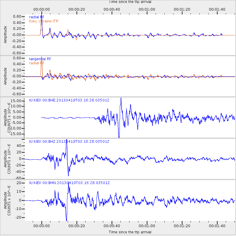
Signal To Noise
| Channel | StoN | STA | LTA |
| IU:KIEV:00:BHZ:20130419T03:16:28.03501Z | 13.545729 | 5.9647873E-6 | 4.403445E-7 |
| IU:KIEV:00:BHN:20130419T03:16:28.03501Z | 9.604134 | 2.260585E-6 | 2.3537626E-7 |
| IU:KIEV:00:BHE:20130419T03:16:28.03501Z | 5.715508 | 1.6592519E-6 | 2.9030699E-7 |
| Arrivals |
| Ps | 4.6 SECOND |
| PpPs | 16 SECOND |
| PsPs/PpSs | 20 SECOND |


