You are here: Home > Network List > TA - USArray Transportable Network (new EarthScope stations) Stations List
> Station I61A Oroboro, Fairlee, VT, USA > Earthquake Result Viewer
I61A Oroboro, Fairlee, VT, USA - Earthquake Result Viewer
| Earthquake location: |
Kuril Islands |
| Earthquake latitude/longitude: |
44.6/148.7 |
| Earthquake time(UTC): |
2014/07/20 (201) 18:32:47 GMT |
| Earthquake Depth: |
61 km |
| Earthquake Magnitude: |
6.6 MB |
| Earthquake Catalog/Contributor: |
NEIC PDE/NEIC COMCAT |
|
| Network: |
TA USArray Transportable Network (new EarthScope stations) |
| Station: |
I61A Oroboro, Fairlee, VT, USA |
| Lat/Lon: |
43.93 N/72.21 W |
| Elevation: |
287 m |
|
| Distance: |
84.6 deg |
| Az: |
28.392 deg |
| Baz: |
331.968 deg |
| Ray Param: |
0.045260254 |
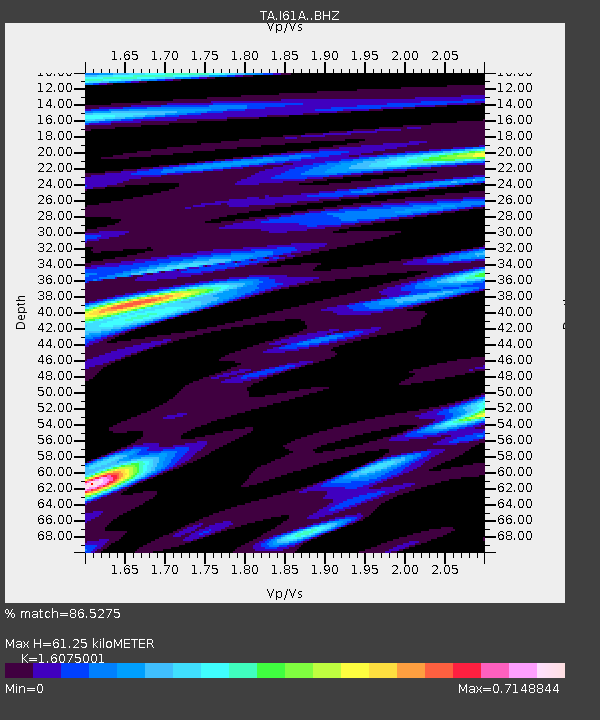
| Estimated Moho Depth: |
61.25 km |
| Estimated Crust Vp/Vs: |
1.61 |
| Assumed Crust Vp: |
6.419 km/s |
| Estimated Crust Vs: |
3.993 km/s |
| Estimated Crust Poisson's Ratio: |
0.18 |
|
| Radial Match: |
86.5275 % |
| Radial Bump: |
400 |
| Transverse Match: |
84.48878 % |
| Transverse Bump: |
400 |
| SOD ConfigId: |
3390531 |
| Insert Time: |
2019-04-12 23:35:24.717 +0000 |
| GWidth: |
2.5 |
| Max Bumps: |
400 |
| Tol: |
0.001 |
|

Signal To Noise
| Channel | StoN | STA | LTA |
| TA:I61A: :BHZ:20140720T18:44:43.22502Z | 33.879684 | 3.7039717E-6 | 1.0932722E-7 |
| TA:I61A: :BHN:20140720T18:44:43.22502Z | 8.64058 | 1.3040562E-6 | 1.509223E-7 |
| TA:I61A: :BHE:20140720T18:44:43.22502Z | 4.564621 | 7.3783315E-7 | 1.6164171E-7 |
| Arrivals |
| Ps | 6.0 SECOND |
| PpPs | 24 SECOND |
| PsPs/PpSs | 30 SECOND |


