You are here: Home > Network List > IW - Intermountain West Stations List
> Station LOHW Long Hollow, Wyoming, USA > Earthquake Result Viewer
LOHW Long Hollow, Wyoming, USA - Earthquake Result Viewer
| Earthquake location: |
Kuril Islands |
| Earthquake latitude/longitude: |
46.2/150.8 |
| Earthquake time(UTC): |
2013/04/19 (109) 03:05:52 GMT |
| Earthquake Depth: |
110 km |
| Earthquake Magnitude: |
7.2 MW, 7.1 MB, 7.2 MW |
| Earthquake Catalog/Contributor: |
NEIC PDE/NEIC PDE-W |
|
| Network: |
IW Intermountain West |
| Station: |
LOHW Long Hollow, Wyoming, USA |
| Lat/Lon: |
43.61 N/110.60 W |
| Elevation: |
2121 m |
|
| Distance: |
65.2 deg |
| Az: |
52.279 deg |
| Baz: |
310.877 deg |
| Ray Param: |
0.05811917 |
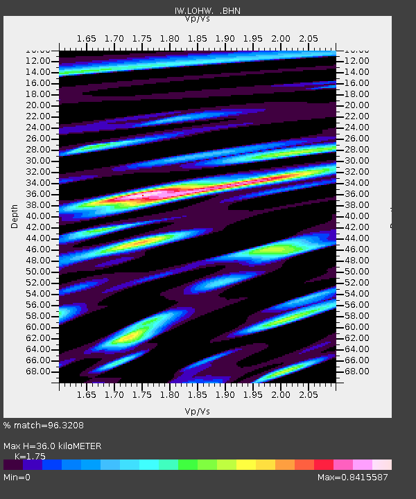
| Estimated Moho Depth: |
36.0 km |
| Estimated Crust Vp/Vs: |
1.75 |
| Assumed Crust Vp: |
6.207 km/s |
| Estimated Crust Vs: |
3.547 km/s |
| Estimated Crust Poisson's Ratio: |
0.26 |
|
| Radial Match: |
96.3208 % |
| Radial Bump: |
400 |
| Transverse Match: |
92.35556 % |
| Transverse Bump: |
400 |
| SOD ConfigId: |
512894 |
| Insert Time: |
2013-09-13 11:18:22.593 +0000 |
| GWidth: |
2.5 |
| Max Bumps: |
400 |
| Tol: |
0.001 |
|

Signal To Noise
| Channel | StoN | STA | LTA |
| IW:LOHW: :BHZ:20130419T03:15:51.564978Z | 46.32812 | 2.584488E-6 | 5.5786593E-8 |
| IW:LOHW: :BHN:20130419T03:15:51.564978Z | 8.270816 | 5.498833E-7 | 6.648477E-8 |
| IW:LOHW: :BHE:20130419T03:15:51.564978Z | 7.6428957 | 7.544439E-7 | 9.871179E-8 |
| Arrivals |
| Ps | 4.5 SECOND |
| PpPs | 15 SECOND |
| PsPs/PpSs | 20 SECOND |


