You are here: Home > Network List > TO - Tectonic Observatory Stations List
> Station CC09 CCSE CC09 > Earthquake Result Viewer
CC09 CCSE CC09 - Earthquake Result Viewer
| Earthquake location: |
Kuril Islands |
| Earthquake latitude/longitude: |
44.6/148.7 |
| Earthquake time(UTC): |
2014/07/20 (201) 18:32:47 GMT |
| Earthquake Depth: |
61 km |
| Earthquake Magnitude: |
6.6 MB |
| Earthquake Catalog/Contributor: |
NEIC PDE/NEIC COMCAT |
|
| Network: |
TO Tectonic Observatory |
| Station: |
CC09 CCSE CC09 |
| Lat/Lon: |
36.02 N/120.89 W |
| Elevation: |
194 m |
|
| Distance: |
66.0 deg |
| Az: |
62.504 deg |
| Baz: |
308.614 deg |
| Ray Param: |
0.057737365 |
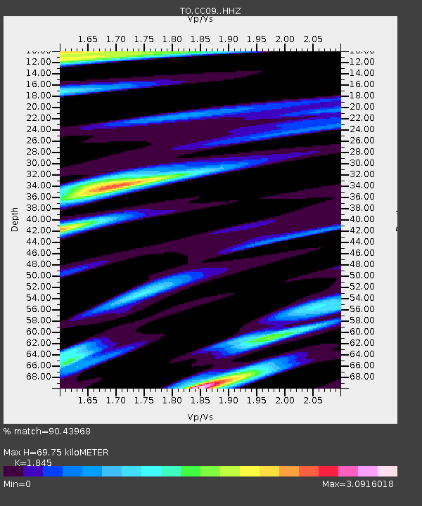
| Estimated Moho Depth: |
69.75 km |
| Estimated Crust Vp/Vs: |
1.85 |
| Assumed Crust Vp: |
6.391 km/s |
| Estimated Crust Vs: |
3.464 km/s |
| Estimated Crust Poisson's Ratio: |
0.29 |
|
| Radial Match: |
90.43968 % |
| Radial Bump: |
400 |
| Transverse Match: |
78.98252 % |
| Transverse Bump: |
400 |
| SOD ConfigId: |
3390531 |
| Insert Time: |
2019-04-12 23:35:59.414 +0000 |
| GWidth: |
2.5 |
| Max Bumps: |
400 |
| Tol: |
0.001 |
|

Signal To Noise
| Channel | StoN | STA | LTA |
| TO:CC09: :HHZ:20140720T18:42:57.05998Z | 7.728277 | 1.4933536E-6 | 1.9323241E-7 |
| TO:CC09: :HHN:20140720T18:42:57.05998Z | 2.650954 | 7.928685E-7 | 2.99088E-7 |
| TO:CC09: :HHE:20140720T18:42:57.05998Z | 3.284893 | 8.6575903E-7 | 2.6355775E-7 |
| Arrivals |
| Ps | 9.6 SECOND |
| PpPs | 30 SECOND |
| PsPs/PpSs | 39 SECOND |


