You are here: Home > Network List > LD - Lamont-Doherty Cooperative Seismographic Network Stations List
> Station FRNY Flat Rock, Altona, NY > Earthquake Result Viewer
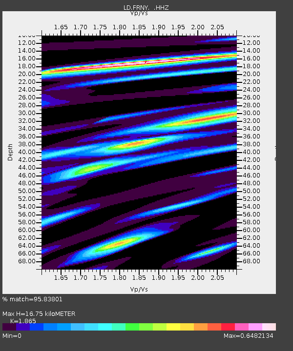
FRNY Flat Rock, Altona, NY - Earthquake Result Viewer
| Earthquake location: |
Kuril Islands |
| Earthquake latitude/longitude: |
46.2/150.8 |
| Earthquake time(UTC): |
2013/04/19 (109) 03:05:52 GMT |
| Earthquake Depth: |
110 km |
| Earthquake Magnitude: |
7.2 MW, 7.1 MB, 7.2 MW |
| Earthquake Catalog/Contributor: |
NEIC PDE/NEIC PDE-W |
|
| Network: |
LD Lamont-Doherty Cooperative Seismographic Network |
| Station: |
FRNY Flat Rock, Altona, NY |
| Lat/Lon: |
44.83 N/73.59 W |
| Elevation: |
242 m |
|
| Distance: |
81.2 deg |
| Az: |
30.232 deg |
| Baz: |
330.572 deg |
| Ray Param: |
0.047488946 |
| Estimated Moho Depth: |
16.75 km |
| Estimated Crust Vp/Vs: |
1.87 |
| Assumed Crust Vp: |
6.419 km/s |
| Estimated Crust Vs: |
3.442 km/s |
| Estimated Crust Poisson's Ratio: |
0.30 |
|
| Radial Match: |
95.83801 % |
| Radial Bump: |
394 |
| Transverse Match: |
82.83013 % |
| Transverse Bump: |
400 |
| SOD ConfigId: |
512894 |
| Insert Time: |
2013-09-13 11:20:42.450 +0000 |
| GWidth: |
2.5 |
| Max Bumps: |
400 |
| Tol: |
0.001 |
|

Signal To Noise
| Channel | StoN | STA | LTA |
| LD:FRNY: :HHZ:20130419T03:17:25.288Z | 19.06593 | 3.8662547E-6 | 2.0278343E-7 |
| LD:FRNY: :HHN:20130419T03:17:25.288Z | 9.035287 | 1.4203554E-6 | 1.5720093E-7 |
| LD:FRNY: :HHE:20130419T03:17:25.288Z | 4.6461987 | 6.2243146E-7 | 1.3396573E-7 |
| Arrivals |
| Ps | 2.3 SECOND |
| PpPs | 7.3 SECOND |
| PsPs/PpSs | 9.6 SECOND |


