You are here: Home > Network List > X812 - Deep Structure of Three Continental Sutures in Eastern North America Stations List
> Station QM33 Maine > Earthquake Result Viewer
QM33 Maine - Earthquake Result Viewer
| Earthquake location: |
Kuril Islands |
| Earthquake latitude/longitude: |
44.6/148.7 |
| Earthquake time(UTC): |
2014/07/20 (201) 18:32:47 GMT |
| Earthquake Depth: |
61 km |
| Earthquake Magnitude: |
6.6 MB |
| Earthquake Catalog/Contributor: |
NEIC PDE/NEIC COMCAT |
|
| Network: |
X8 Deep Structure of Three Continental Sutures in Eastern North America |
| Station: |
QM33 Maine |
| Lat/Lon: |
47.21 N/69.40 W |
| Elevation: |
0.0 m |
|
| Distance: |
82.6 deg |
| Az: |
25.119 deg |
| Baz: |
333.599 deg |
| Ray Param: |
0.04668026 |
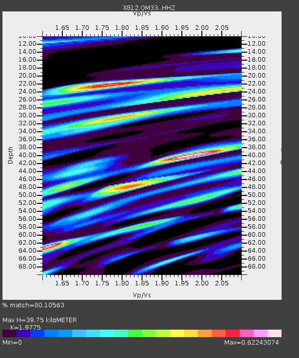
| Estimated Moho Depth: |
39.75 km |
| Estimated Crust Vp/Vs: |
1.98 |
| Assumed Crust Vp: |
6.419 km/s |
| Estimated Crust Vs: |
3.246 km/s |
| Estimated Crust Poisson's Ratio: |
0.33 |
|
| Radial Match: |
80.10563 % |
| Radial Bump: |
400 |
| Transverse Match: |
65.72863 % |
| Transverse Bump: |
400 |
| SOD ConfigId: |
3390531 |
| Insert Time: |
2019-04-12 23:37:00.592 +0000 |
| GWidth: |
2.5 |
| Max Bumps: |
400 |
| Tol: |
0.001 |
|
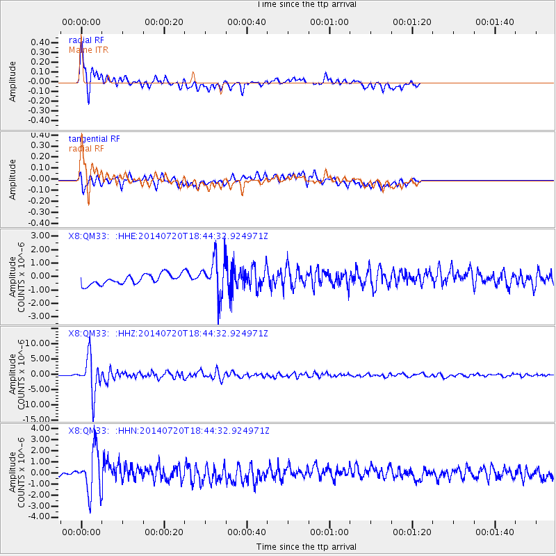
Signal To Noise
| Channel | StoN | STA | LTA |
| X8:QM33: :HHZ:20140720T18:44:32.924971Z | 38.956142 | 6.1223864E-6 | 1.57161E-7 |
| X8:QM33: :HHN:20140720T18:44:32.924971Z | 9.060993 | 1.9837764E-6 | 2.1893587E-7 |
| X8:QM33: :HHE:20140720T18:44:32.924971Z | 3.8708022 | 1.4235789E-6 | 3.677736E-7 |
| Arrivals |
| Ps | 6.2 SECOND |
| PpPs | 18 SECOND |
| PsPs/PpSs | 24 SECOND |


