You are here: Home > Network List > X812 - Deep Structure of Three Continental Sutures in Eastern North America Stations List
> Station QM34 Ferme Vifranc, St-Pamphile, Quebec, Canada > Earthquake Result Viewer
QM34 Ferme Vifranc, St-Pamphile, Quebec, Canada - Earthquake Result Viewer
| Earthquake location: |
Kuril Islands |
| Earthquake latitude/longitude: |
44.6/148.7 |
| Earthquake time(UTC): |
2014/07/20 (201) 18:32:47 GMT |
| Earthquake Depth: |
61 km |
| Earthquake Magnitude: |
6.6 MB |
| Earthquake Catalog/Contributor: |
NEIC PDE/NEIC COMCAT |
|
| Network: |
X8 Deep Structure of Three Continental Sutures in Eastern North America |
| Station: |
QM34 Ferme Vifranc, St-Pamphile, Quebec, Canada |
| Lat/Lon: |
47.02 N/69.83 W |
| Elevation: |
374 m |
|
| Distance: |
82.6 deg |
| Az: |
25.47 deg |
| Baz: |
333.332 deg |
| Ray Param: |
0.04665084 |
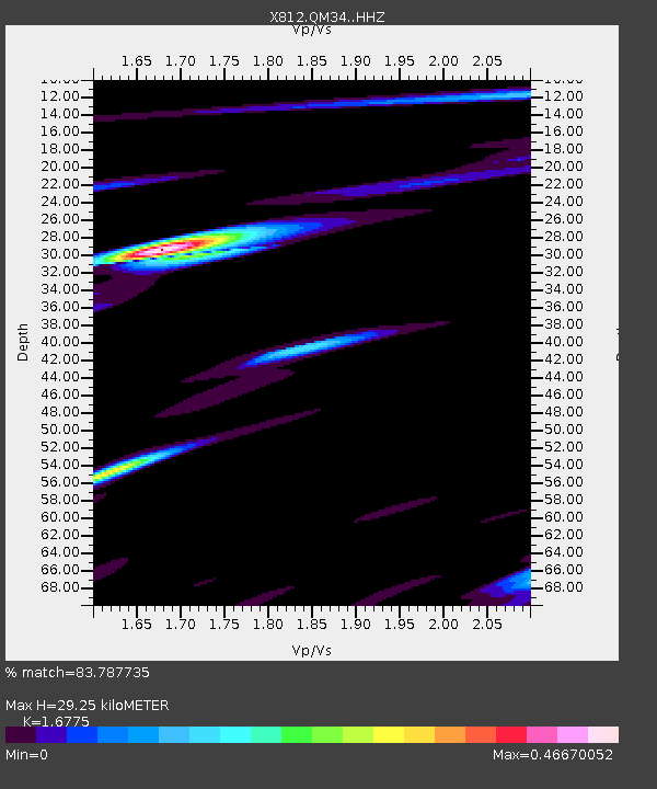
| Estimated Moho Depth: |
29.25 km |
| Estimated Crust Vp/Vs: |
1.68 |
| Assumed Crust Vp: |
6.419 km/s |
| Estimated Crust Vs: |
3.827 km/s |
| Estimated Crust Poisson's Ratio: |
0.22 |
|
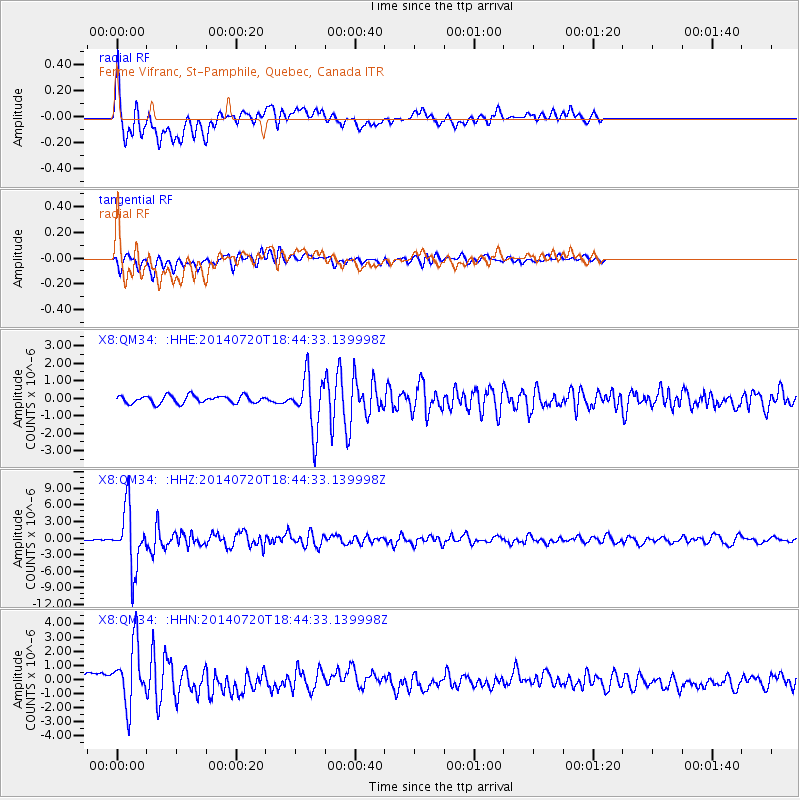
| Radial Match: |
83.787735 % |
| Radial Bump: |
400 |
| Transverse Match: |
72.584114 % |
| Transverse Bump: |
400 |
| SOD ConfigId: |
3390531 |
| Insert Time: |
2019-04-12 23:37:02.299 +0000 |
| GWidth: |
2.5 |
| Max Bumps: |
400 |
| Tol: |
0.001 |
|
Signal To Noise
| Channel | StoN | STA | LTA |
| X8:QM34: :HHZ:20140720T18:44:33.139998Z | 27.510841 | 5.338311E-6 | 1.940439E-7 |
| X8:QM34: :HHN:20140720T18:44:33.139998Z | 10.95553 | 2.1950225E-6 | 2.0035749E-7 |
| X8:QM34: :HHE:20140720T18:44:33.139998Z | 7.149489 | 1.549524E-6 | 2.1673213E-7 |
| Arrivals |
| Ps | 3.2 SECOND |
| PpPs | 12 SECOND |
| PsPs/PpSs | 15 SECOND |


