You are here: Home > Network List > X812 - Deep Structure of Three Continental Sutures in Eastern North America Stations List
> Station QM44 UQAR experimental forest, Saguenay, Quebec, Canada > Earthquake Result Viewer
QM44 UQAR experimental forest, Saguenay, Quebec, Canada - Earthquake Result Viewer
| Earthquake location: |
Kuril Islands |
| Earthquake latitude/longitude: |
44.6/148.7 |
| Earthquake time(UTC): |
2014/07/20 (201) 18:32:47 GMT |
| Earthquake Depth: |
61 km |
| Earthquake Magnitude: |
6.6 MB |
| Earthquake Catalog/Contributor: |
NEIC PDE/NEIC COMCAT |
|
| Network: |
X8 Deep Structure of Three Continental Sutures in Eastern North America |
| Station: |
QM44 UQAR experimental forest, Saguenay, Quebec, Canada |
| Lat/Lon: |
48.20 N/71.19 W |
| Elevation: |
352 m |
|
| Distance: |
81.1 deg |
| Az: |
25.753 deg |
| Baz: |
332.368 deg |
| Ray Param: |
0.047677986 |
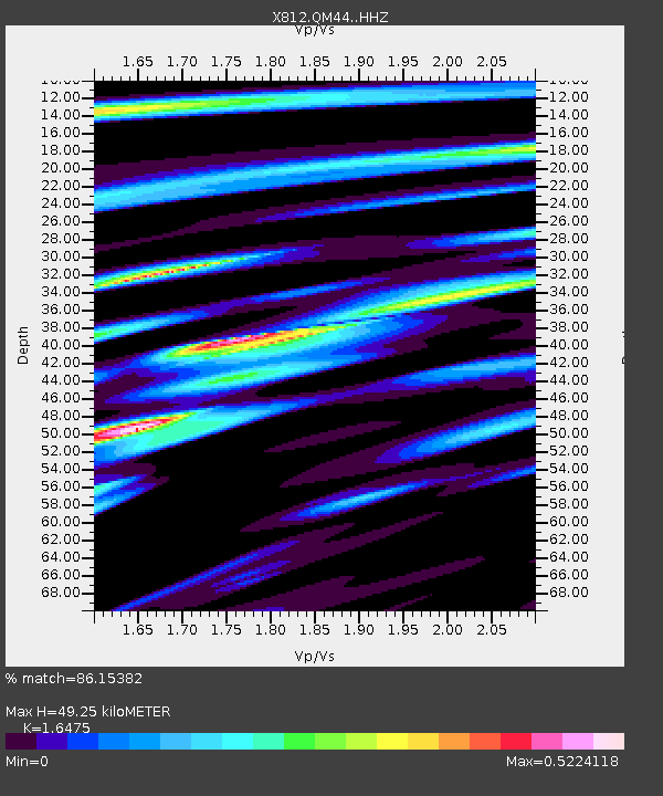
| Estimated Moho Depth: |
49.25 km |
| Estimated Crust Vp/Vs: |
1.65 |
| Assumed Crust Vp: |
6.61 km/s |
| Estimated Crust Vs: |
4.012 km/s |
| Estimated Crust Poisson's Ratio: |
0.21 |
|
| Radial Match: |
86.15382 % |
| Radial Bump: |
400 |
| Transverse Match: |
71.09784 % |
| Transverse Bump: |
400 |
| SOD ConfigId: |
3390531 |
| Insert Time: |
2019-04-12 23:37:04.299 +0000 |
| GWidth: |
2.5 |
| Max Bumps: |
400 |
| Tol: |
0.001 |
|

Signal To Noise
| Channel | StoN | STA | LTA |
| X8:QM44: :HHZ:20140720T18:44:25.429976Z | 41.607204 | 4.827817E-6 | 1.160332E-7 |
| X8:QM44: :HHN:20140720T18:44:25.429976Z | 7.6008015 | 1.4170314E-6 | 1.8643183E-7 |
| X8:QM44: :HHE:20140720T18:44:25.429976Z | 3.886663 | 7.0804145E-7 | 1.8217207E-7 |
| Arrivals |
| Ps | 5.0 SECOND |
| PpPs | 19 SECOND |
| PsPs/PpSs | 24 SECOND |


