You are here: Home > Network List > X812 - Deep Structure of Three Continental Sutures in Eastern North America Stations List
> Station QM60 Rte R0203, Quebec, Canada > Earthquake Result Viewer
QM60 Rte R0203, Quebec, Canada - Earthquake Result Viewer
| Earthquake location: |
Kuril Islands |
| Earthquake latitude/longitude: |
44.6/148.7 |
| Earthquake time(UTC): |
2014/07/20 (201) 18:32:47 GMT |
| Earthquake Depth: |
61 km |
| Earthquake Magnitude: |
6.6 MB |
| Earthquake Catalog/Contributor: |
NEIC PDE/NEIC COMCAT |
|
| Network: |
X8 Deep Structure of Three Continental Sutures in Eastern North America |
| Station: |
QM60 Rte R0203, Quebec, Canada |
| Lat/Lon: |
49.17 N/73.34 W |
| Elevation: |
354 m |
|
| Distance: |
79.6 deg |
| Az: |
26.555 deg |
| Baz: |
330.898 deg |
| Ray Param: |
0.048719835 |
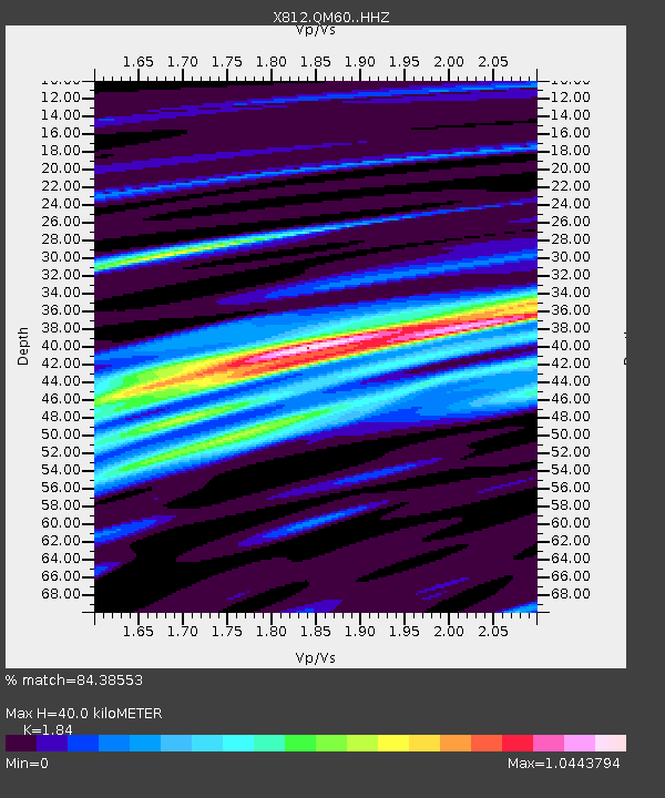
| Estimated Moho Depth: |
40.0 km |
| Estimated Crust Vp/Vs: |
1.84 |
| Assumed Crust Vp: |
6.61 km/s |
| Estimated Crust Vs: |
3.592 km/s |
| Estimated Crust Poisson's Ratio: |
0.29 |
|
| Radial Match: |
84.38553 % |
| Radial Bump: |
400 |
| Transverse Match: |
67.76138 % |
| Transverse Bump: |
400 |
| SOD ConfigId: |
3390531 |
| Insert Time: |
2019-04-12 23:37:07.099 +0000 |
| GWidth: |
2.5 |
| Max Bumps: |
400 |
| Tol: |
0.001 |
|

Signal To Noise
| Channel | StoN | STA | LTA |
| X8:QM60: :HHZ:20140720T18:44:17.285017Z | 40.644592 | 6.413763E-6 | 1.5780115E-7 |
| X8:QM60: :HHN:20140720T18:44:17.285017Z | 12.871572 | 2.726202E-6 | 2.1180026E-7 |
| X8:QM60: :HHE:20140720T18:44:17.285017Z | 6.3188133 | 1.6497493E-6 | 2.610853E-7 |
| Arrivals |
| Ps | 5.2 SECOND |
| PpPs | 17 SECOND |
| PsPs/PpSs | 22 SECOND |


