You are here: Home > Network List > LD - Lamont-Doherty Cooperative Seismographic Network Stations List
> Station PANJ Princeton, NJ > Earthquake Result Viewer
PANJ Princeton, NJ - Earthquake Result Viewer
| Earthquake location: |
Kuril Islands |
| Earthquake latitude/longitude: |
46.2/150.8 |
| Earthquake time(UTC): |
2013/04/19 (109) 03:05:52 GMT |
| Earthquake Depth: |
110 km |
| Earthquake Magnitude: |
7.2 MW, 7.1 MB, 7.2 MW |
| Earthquake Catalog/Contributor: |
NEIC PDE/NEIC PDE-W |
|
| Network: |
LD Lamont-Doherty Cooperative Seismographic Network |
| Station: |
PANJ Princeton, NJ |
| Lat/Lon: |
40.38 N/74.70 W |
| Elevation: |
100 m |
|
| Distance: |
84.7 deg |
| Az: |
33.171 deg |
| Baz: |
330.181 deg |
| Ray Param: |
0.045062553 |
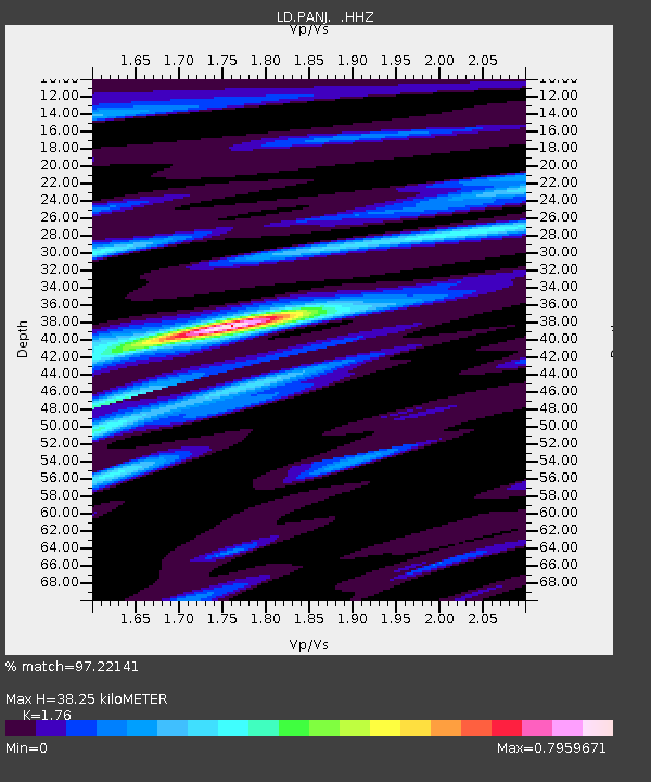
| Estimated Moho Depth: |
38.25 km |
| Estimated Crust Vp/Vs: |
1.76 |
| Assumed Crust Vp: |
6.283 km/s |
| Estimated Crust Vs: |
3.57 km/s |
| Estimated Crust Poisson's Ratio: |
0.26 |
|
| Radial Match: |
97.22141 % |
| Radial Bump: |
287 |
| Transverse Match: |
91.963234 % |
| Transverse Bump: |
399 |
| SOD ConfigId: |
512894 |
| Insert Time: |
2013-09-13 11:21:29.358 +0000 |
| GWidth: |
2.5 |
| Max Bumps: |
400 |
| Tol: |
0.001 |
|

Signal To Noise
| Channel | StoN | STA | LTA |
| LD:PANJ: :HHZ:20130419T03:17:43.077979Z | 22.30065 | 5.562643E-6 | 2.4943859E-7 |
| LD:PANJ: :HHN:20130419T03:17:43.077979Z | 7.4336143 | 1.6652872E-6 | 2.2402119E-7 |
| LD:PANJ: :HHE:20130419T03:17:43.077979Z | 5.953658 | 9.214011E-7 | 1.5476218E-7 |
| Arrivals |
| Ps | 4.7 SECOND |
| PpPs | 16 SECOND |
| PsPs/PpSs | 21 SECOND |


