You are here: Home > Network List > X812 - Deep Structure of Three Continental Sutures in Eastern North America Stations List
> Station QM80 Route du Nord, Quebec, Canada > Earthquake Result Viewer
QM80 Route du Nord, Quebec, Canada - Earthquake Result Viewer
| Earthquake location: |
Kuril Islands |
| Earthquake latitude/longitude: |
44.6/148.7 |
| Earthquake time(UTC): |
2014/07/20 (201) 18:32:47 GMT |
| Earthquake Depth: |
61 km |
| Earthquake Magnitude: |
6.6 MB |
| Earthquake Catalog/Contributor: |
NEIC PDE/NEIC COMCAT |
|
| Network: |
X8 Deep Structure of Three Continental Sutures in Eastern North America |
| Station: |
QM80 Route du Nord, Quebec, Canada |
| Lat/Lon: |
50.96 N/75.23 W |
| Elevation: |
371 m |
|
| Distance: |
77.5 deg |
| Az: |
26.721 deg |
| Baz: |
329.486 deg |
| Ray Param: |
0.05019232 |
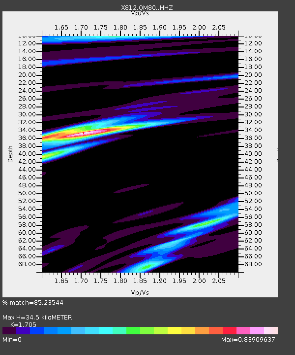
| Estimated Moho Depth: |
34.5 km |
| Estimated Crust Vp/Vs: |
1.71 |
| Assumed Crust Vp: |
6.61 km/s |
| Estimated Crust Vs: |
3.877 km/s |
| Estimated Crust Poisson's Ratio: |
0.24 |
|
| Radial Match: |
85.23544 % |
| Radial Bump: |
400 |
| Transverse Match: |
79.10111 % |
| Transverse Bump: |
400 |
| SOD ConfigId: |
3390531 |
| Insert Time: |
2019-04-12 23:37:14.042 +0000 |
| GWidth: |
2.5 |
| Max Bumps: |
400 |
| Tol: |
0.001 |
|

Signal To Noise
| Channel | StoN | STA | LTA |
| X8:QM80: :HHZ:20140720T18:44:05.400007Z | 73.27069 | 6.6250227E-6 | 9.041845E-8 |
| X8:QM80: :HHN:20140720T18:44:05.400007Z | 9.515451 | 2.0029065E-6 | 2.104899E-7 |
| X8:QM80: :HHE:20140720T18:44:05.400007Z | 6.851948 | 1.6589019E-6 | 2.4210664E-7 |
| Arrivals |
| Ps | 3.8 SECOND |
| PpPs | 14 SECOND |
| PsPs/PpSs | 17 SECOND |


