You are here: Home > Network List > ND - New CaleDonia Broadband Seismic Network Stations List
> Station MARNC Mare, Loyalty islands, New Caledonia > Earthquake Result Viewer
MARNC Mare, Loyalty islands, New Caledonia - Earthquake Result Viewer
| Earthquake location: |
Kuril Islands |
| Earthquake latitude/longitude: |
46.2/150.8 |
| Earthquake time(UTC): |
2013/04/19 (109) 03:05:52 GMT |
| Earthquake Depth: |
110 km |
| Earthquake Magnitude: |
7.2 MW, 7.1 MB, 7.2 MW |
| Earthquake Catalog/Contributor: |
NEIC PDE/NEIC PDE-W |
|
| Network: |
ND New CaleDonia Broadband Seismic Network |
| Station: |
MARNC Mare, Loyalty islands, New Caledonia |
| Lat/Lon: |
21.48 S/168.03 E |
| Elevation: |
44 m |
|
| Distance: |
69.2 deg |
| Az: |
162.82 deg |
| Baz: |
347.28 deg |
| Ray Param: |
0.055539686 |
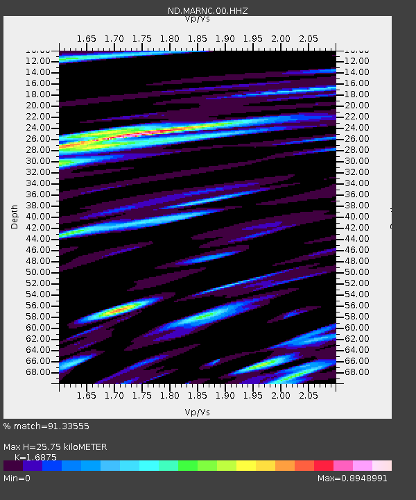
| Estimated Moho Depth: |
25.75 km |
| Estimated Crust Vp/Vs: |
1.69 |
| Assumed Crust Vp: |
4.082 km/s |
| Estimated Crust Vs: |
2.419 km/s |
| Estimated Crust Poisson's Ratio: |
0.23 |
|
| Radial Match: |
91.33555 % |
| Radial Bump: |
306 |
| Transverse Match: |
79.15299 % |
| Transverse Bump: |
400 |
| SOD ConfigId: |
512894 |
| Insert Time: |
2013-09-13 11:22:35.574 +0000 |
| GWidth: |
2.5 |
| Max Bumps: |
400 |
| Tol: |
0.001 |
|
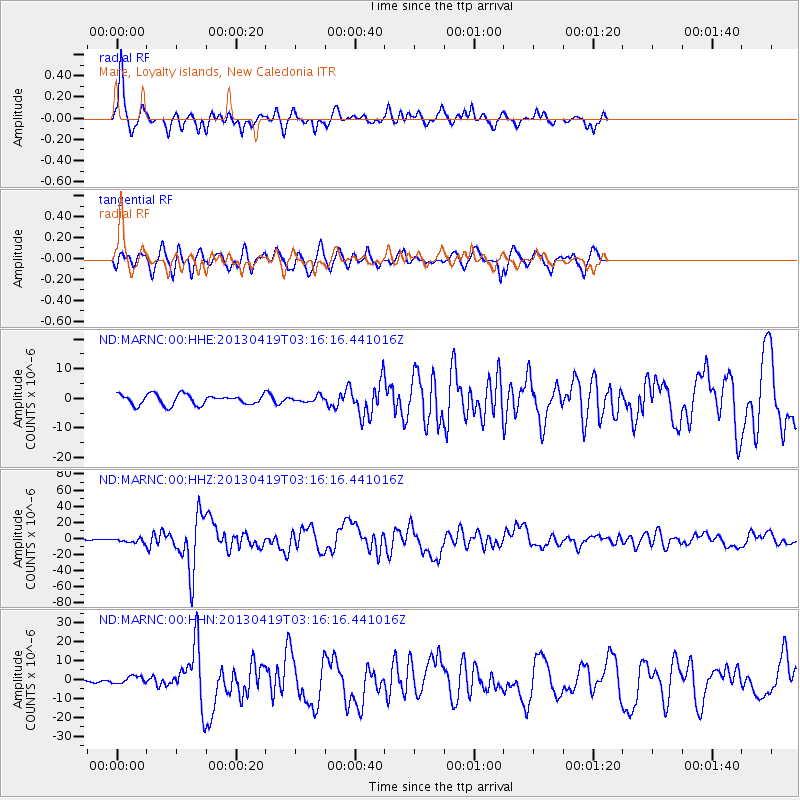
Signal To Noise
| Channel | StoN | STA | LTA |
| ND:MARNC:00:HHZ:20130419T03:16:16.441016Z | 4.638391 | 2.7020897E-6 | 5.8254886E-7 |
| ND:MARNC:00:HHN:20130419T03:16:16.441016Z | 1.1159831 | 1.9919146E-6 | 1.7848968E-6 |
| ND:MARNC:00:HHE:20130419T03:16:16.441016Z | 0.5667922 | 9.871495E-7 | 1.7416429E-6 |
| Arrivals |
| Ps | 4.4 SECOND |
| PpPs | 17 SECOND |
| PsPs/PpSs | 21 SECOND |


