You are here: Home > Network List > NE - New England Seismic Network Stations List
> Station TRY Troy, NY, USA > Earthquake Result Viewer
TRY Troy, NY, USA - Earthquake Result Viewer
| Earthquake location: |
Kuril Islands |
| Earthquake latitude/longitude: |
46.2/150.8 |
| Earthquake time(UTC): |
2013/04/19 (109) 03:05:52 GMT |
| Earthquake Depth: |
110 km |
| Earthquake Magnitude: |
7.2 MW, 7.1 MB, 7.2 MW |
| Earthquake Catalog/Contributor: |
NEIC PDE/NEIC PDE-W |
|
| Network: |
NE New England Seismic Network |
| Station: |
TRY Troy, NY, USA |
| Lat/Lon: |
42.73 N/73.67 W |
| Elevation: |
89 m |
|
| Distance: |
83.0 deg |
| Az: |
31.323 deg |
| Baz: |
330.668 deg |
| Ray Param: |
0.04623613 |
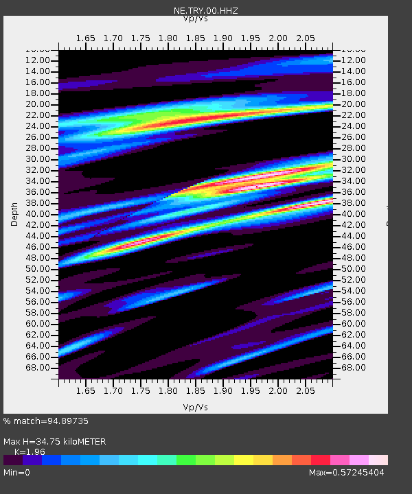
| Estimated Moho Depth: |
34.75 km |
| Estimated Crust Vp/Vs: |
1.96 |
| Assumed Crust Vp: |
6.419 km/s |
| Estimated Crust Vs: |
3.275 km/s |
| Estimated Crust Poisson's Ratio: |
0.32 |
|
| Radial Match: |
94.89735 % |
| Radial Bump: |
400 |
| Transverse Match: |
87.29645 % |
| Transverse Bump: |
400 |
| SOD ConfigId: |
512894 |
| Insert Time: |
2013-09-13 11:23:05.264 +0000 |
| GWidth: |
2.5 |
| Max Bumps: |
400 |
| Tol: |
0.001 |
|

Signal To Noise
| Channel | StoN | STA | LTA |
| NE:TRY:00:HHZ:20130419T03:17:34.673987Z | 29.743324 | 3.7806828E-6 | 1.271103E-7 |
| NE:TRY:00:HH1:20130419T03:17:34.673987Z | 7.703306 | 1.4058315E-6 | 1.8249717E-7 |
| NE:TRY:00:HH2:20130419T03:17:34.673987Z | 7.6726294 | 1.0197217E-6 | 1.329038E-7 |
| Arrivals |
| Ps | 5.3 SECOND |
| PpPs | 16 SECOND |
| PsPs/PpSs | 21 SECOND |


