You are here: Home > Network List > NE - New England Seismic Network Stations List
> Station WVL Waterville, ME, USA > Earthquake Result Viewer
WVL Waterville, ME, USA - Earthquake Result Viewer
| Earthquake location: |
Kuril Islands |
| Earthquake latitude/longitude: |
46.2/150.8 |
| Earthquake time(UTC): |
2013/04/19 (109) 03:05:52 GMT |
| Earthquake Depth: |
110 km |
| Earthquake Magnitude: |
7.2 MW, 7.1 MB, 7.2 MW |
| Earthquake Catalog/Contributor: |
NEIC PDE/NEIC PDE-W |
|
| Network: |
NE New England Seismic Network |
| Station: |
WVL Waterville, ME, USA |
| Lat/Lon: |
44.56 N/69.66 W |
| Elevation: |
50 m |
|
| Distance: |
82.8 deg |
| Az: |
27.869 deg |
| Baz: |
332.997 deg |
| Ray Param: |
0.046406534 |
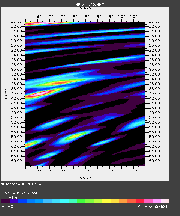
| Estimated Moho Depth: |
39.75 km |
| Estimated Crust Vp/Vs: |
1.66 |
| Assumed Crust Vp: |
6.419 km/s |
| Estimated Crust Vs: |
3.867 km/s |
| Estimated Crust Poisson's Ratio: |
0.22 |
|
| Radial Match: |
96.281784 % |
| Radial Bump: |
400 |
| Transverse Match: |
90.31051 % |
| Transverse Bump: |
400 |
| SOD ConfigId: |
512894 |
| Insert Time: |
2013-09-13 11:23:24.154 +0000 |
| GWidth: |
2.5 |
| Max Bumps: |
400 |
| Tol: |
0.001 |
|

Signal To Noise
| Channel | StoN | STA | LTA |
| NE:WVL:00:HHZ:20130419T03:17:33.423987Z | 17.42452 | 5.44229E-6 | 3.1233515E-7 |
| NE:WVL:00:HH1:20130419T03:17:33.423987Z | 6.549791 | 1.7554053E-6 | 2.6800936E-7 |
| NE:WVL:00:HH2:20130419T03:17:33.423987Z | 3.0376186 | 8.524757E-7 | 2.8063948E-7 |
| Arrivals |
| Ps | 4.2 SECOND |
| PpPs | 16 SECOND |
| PsPs/PpSs | 20 SECOND |


