You are here: Home > Network List > NI - North-East Italy Broadband Network Stations List
> Station ACOM Acomizza > Earthquake Result Viewer
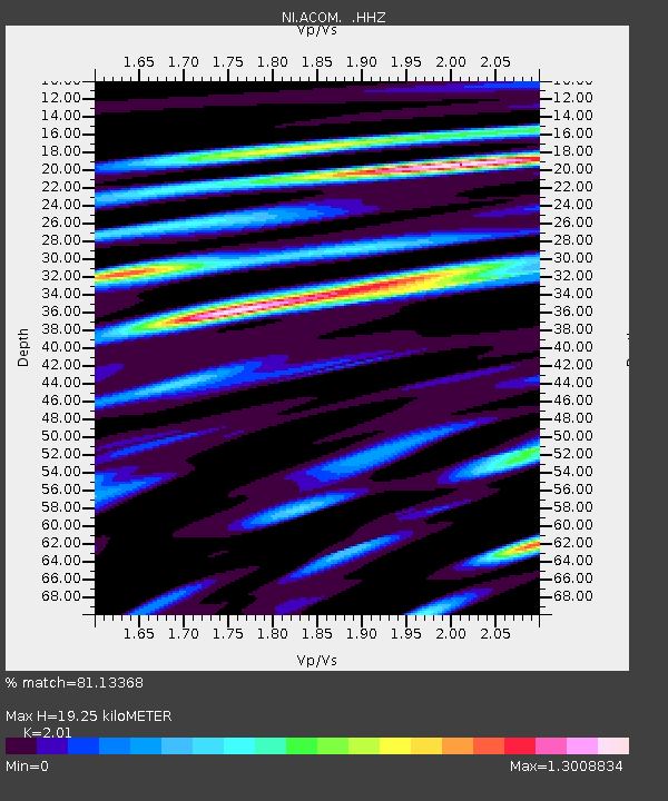
ACOM Acomizza - Earthquake Result Viewer
| Earthquake location: |
Kuril Islands |
| Earthquake latitude/longitude: |
46.2/150.8 |
| Earthquake time(UTC): |
2013/04/19 (109) 03:05:52 GMT |
| Earthquake Depth: |
110 km |
| Earthquake Magnitude: |
7.2 MW, 7.1 MB, 7.2 MW |
| Earthquake Catalog/Contributor: |
NEIC PDE/NEIC PDE-W |
|
| Network: |
NI North-East Italy Broadband Network |
| Station: |
ACOM Acomizza |
| Lat/Lon: |
46.55 N/13.51 E |
| Elevation: |
1788 m |
|
| Distance: |
80.3 deg |
| Az: |
331.635 deg |
| Baz: |
28.55 deg |
| Ray Param: |
0.04813584 |
| Estimated Moho Depth: |
19.25 km |
| Estimated Crust Vp/Vs: |
2.01 |
| Assumed Crust Vp: |
6.35 km/s |
| Estimated Crust Vs: |
3.159 km/s |
| Estimated Crust Poisson's Ratio: |
0.34 |
|
| Radial Match: |
81.13368 % |
| Radial Bump: |
400 |
| Transverse Match: |
77.7048 % |
| Transverse Bump: |
400 |
| SOD ConfigId: |
512894 |
| Insert Time: |
2013-09-13 11:23:30.710 +0000 |
| GWidth: |
2.5 |
| Max Bumps: |
400 |
| Tol: |
0.001 |
|

Signal To Noise
| Channel | StoN | STA | LTA |
| NI:ACOM: :HHZ:20130419T03:17:20.31803Z | 42.30196 | 5.70759E-6 | 1.3492496E-7 |
| NI:ACOM: :HHN:20130419T03:17:20.31803Z | 9.627085 | 1.4980697E-6 | 1.556099E-7 |
| NI:ACOM: :HHE:20130419T03:17:20.31803Z | 9.810615 | 2.029701E-6 | 2.0688823E-7 |
| Arrivals |
| Ps | 3.1 SECOND |
| PpPs | 8.9 SECOND |
| PsPs/PpSs | 12 SECOND |


