You are here: Home > Network List > NI - North-East Italy Broadband Network Stations List
> Station CIMO Cimolais > Earthquake Result Viewer
CIMO Cimolais - Earthquake Result Viewer
| Earthquake location: |
Kuril Islands |
| Earthquake latitude/longitude: |
46.2/150.8 |
| Earthquake time(UTC): |
2013/04/19 (109) 03:05:52 GMT |
| Earthquake Depth: |
110 km |
| Earthquake Magnitude: |
7.2 MW, 7.1 MB, 7.2 MW |
| Earthquake Catalog/Contributor: |
NEIC PDE/NEIC PDE-W |
|
| Network: |
NI North-East Italy Broadband Network |
| Station: |
CIMO Cimolais |
| Lat/Lon: |
46.31 N/12.44 E |
| Elevation: |
728 m |
|
| Distance: |
80.8 deg |
| Az: |
332.182 deg |
| Baz: |
27.868 deg |
| Ray Param: |
0.047754336 |
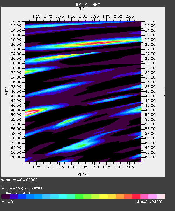
| Estimated Moho Depth: |
49.0 km |
| Estimated Crust Vp/Vs: |
1.61 |
| Assumed Crust Vp: |
6.35 km/s |
| Estimated Crust Vs: |
3.938 km/s |
| Estimated Crust Poisson's Ratio: |
0.19 |
|
| Radial Match: |
84.07909 % |
| Radial Bump: |
400 |
| Transverse Match: |
77.18001 % |
| Transverse Bump: |
400 |
| SOD ConfigId: |
512894 |
| Insert Time: |
2013-09-13 11:23:36.776 +0000 |
| GWidth: |
2.5 |
| Max Bumps: |
400 |
| Tol: |
0.001 |
|

Signal To Noise
| Channel | StoN | STA | LTA |
| NI:CIMO: :HHZ:20130419T03:17:23.288Z | 15.450297 | 3.7875952E-6 | 2.4514708E-7 |
| NI:CIMO: :HHN:20130419T03:17:23.288Z | 6.92654 | 9.3156234E-7 | 1.3449173E-7 |
| NI:CIMO: :HHE:20130419T03:17:23.288Z | 8.441771 | 8.0288186E-7 | 9.5108234E-8 |
| Arrivals |
| Ps | 4.9 SECOND |
| PpPs | 20 SECOND |
| PsPs/PpSs | 24 SECOND |


