You are here: Home > Network List > NI - North-East Italy Broadband Network Stations List
> Station FUSE Fusea > Earthquake Result Viewer
FUSE Fusea - Earthquake Result Viewer
| Earthquake location: |
Kuril Islands |
| Earthquake latitude/longitude: |
46.2/150.8 |
| Earthquake time(UTC): |
2013/04/19 (109) 03:05:52 GMT |
| Earthquake Depth: |
110 km |
| Earthquake Magnitude: |
7.2 MW, 7.1 MB, 7.2 MW |
| Earthquake Catalog/Contributor: |
NEIC PDE/NEIC PDE-W |
|
| Network: |
NI North-East Italy Broadband Network |
| Station: |
FUSE Fusea |
| Lat/Lon: |
46.41 N/13.00 E |
| Elevation: |
574 m |
|
| Distance: |
80.6 deg |
| Az: |
331.886 deg |
| Baz: |
28.222 deg |
| Ray Param: |
0.047943395 |
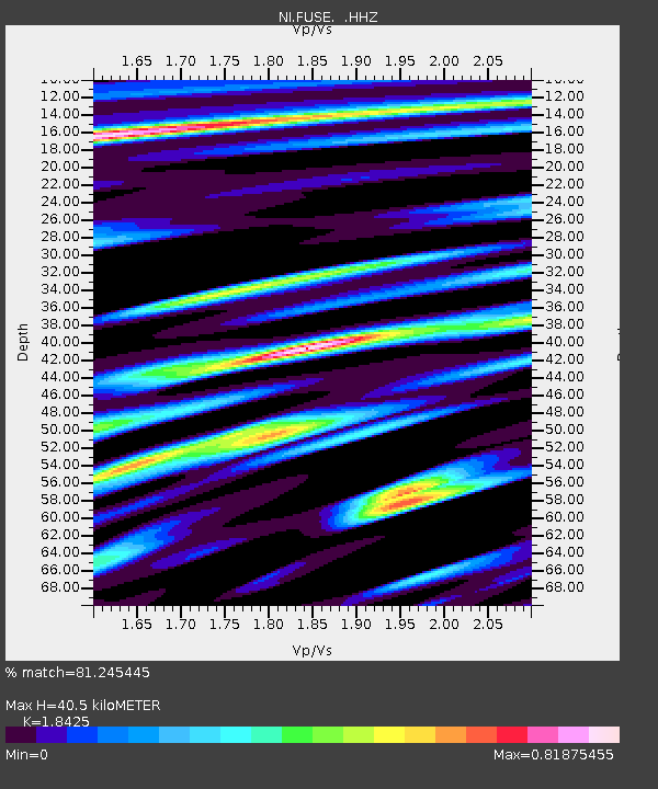
| Estimated Moho Depth: |
40.5 km |
| Estimated Crust Vp/Vs: |
1.84 |
| Assumed Crust Vp: |
6.35 km/s |
| Estimated Crust Vs: |
3.446 km/s |
| Estimated Crust Poisson's Ratio: |
0.29 |
|
| Radial Match: |
81.245445 % |
| Radial Bump: |
400 |
| Transverse Match: |
72.93309 % |
| Transverse Bump: |
400 |
| SOD ConfigId: |
512894 |
| Insert Time: |
2013-09-13 11:23:44.075 +0000 |
| GWidth: |
2.5 |
| Max Bumps: |
400 |
| Tol: |
0.001 |
|

Signal To Noise
| Channel | StoN | STA | LTA |
| NI:FUSE: :HHZ:20130419T03:17:21.837988Z | 21.805553 | 3.7423424E-6 | 1.7162336E-7 |
| NI:FUSE: :HHN:20130419T03:17:21.837988Z | 4.122469 | 1.2294762E-6 | 2.9823784E-7 |
| NI:FUSE: :HHE:20130419T03:17:21.837988Z | 2.795791 | 6.1846964E-7 | 2.2121455E-7 |
| Arrivals |
| Ps | 5.5 SECOND |
| PpPs | 18 SECOND |
| PsPs/PpSs | 23 SECOND |


