You are here: Home > Network List > NM - Cooperative New Madrid Seismic Network Stations List
> Station GNAR Gosnell,AR > Earthquake Result Viewer
GNAR Gosnell,AR - Earthquake Result Viewer
| Earthquake location: |
Kuril Islands |
| Earthquake latitude/longitude: |
46.2/150.8 |
| Earthquake time(UTC): |
2013/04/19 (109) 03:05:52 GMT |
| Earthquake Depth: |
110 km |
| Earthquake Magnitude: |
7.2 MW, 7.1 MB, 7.2 MW |
| Earthquake Catalog/Contributor: |
NEIC PDE/NEIC PDE-W |
|
| Network: |
NM Cooperative New Madrid Seismic Network |
| Station: |
GNAR Gosnell,AR |
| Lat/Lon: |
35.97 N/90.02 W |
| Elevation: |
71 m |
|
| Distance: |
81.6 deg |
| Az: |
45.715 deg |
| Baz: |
322.217 deg |
| Ray Param: |
0.04722386 |
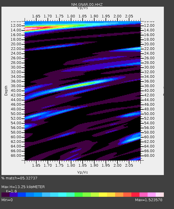
| Estimated Moho Depth: |
13.25 km |
| Estimated Crust Vp/Vs: |
1.60 |
| Assumed Crust Vp: |
6.273 km/s |
| Estimated Crust Vs: |
3.921 km/s |
| Estimated Crust Poisson's Ratio: |
0.18 |
|
| Radial Match: |
85.32737 % |
| Radial Bump: |
400 |
| Transverse Match: |
81.66187 % |
| Transverse Bump: |
400 |
| SOD ConfigId: |
512894 |
| Insert Time: |
2013-09-13 11:24:13.983 +0000 |
| GWidth: |
2.5 |
| Max Bumps: |
400 |
| Tol: |
0.001 |
|

Signal To Noise
| Channel | StoN | STA | LTA |
| NM:GNAR:00:HHZ:20130419T03:17:27.275Z | 28.415987 | 8.310368E-6 | 2.9245396E-7 |
| NM:GNAR:00:HHN:20130419T03:17:27.275Z | 2.010277 | 2.2901418E-6 | 1.1392169E-6 |
| NM:GNAR:00:HHE:20130419T03:17:27.275Z | 1.4728045 | 2.404407E-6 | 1.6325364E-6 |
| Arrivals |
| Ps | 1.3 SECOND |
| PpPs | 5.3 SECOND |
| PsPs/PpSs | 6.6 SECOND |


