You are here: Home > Network List > NM - Cooperative New Madrid Seismic Network Stations List
> Station UALR University of Arkansas, Little Rock > Earthquake Result Viewer
UALR University of Arkansas, Little Rock - Earthquake Result Viewer
| Earthquake location: |
Kuril Islands |
| Earthquake latitude/longitude: |
46.2/150.8 |
| Earthquake time(UTC): |
2013/04/19 (109) 03:05:52 GMT |
| Earthquake Depth: |
110 km |
| Earthquake Magnitude: |
7.2 MW, 7.1 MB, 7.2 MW |
| Earthquake Catalog/Contributor: |
NEIC PDE/NEIC PDE-W |
|
| Network: |
NM Cooperative New Madrid Seismic Network |
| Station: |
UALR University of Arkansas, Little Rock |
| Lat/Lon: |
34.78 N/92.34 W |
| Elevation: |
138 m |
|
| Distance: |
81.4 deg |
| Az: |
47.967 deg |
| Baz: |
321.21 deg |
| Ray Param: |
0.047395717 |
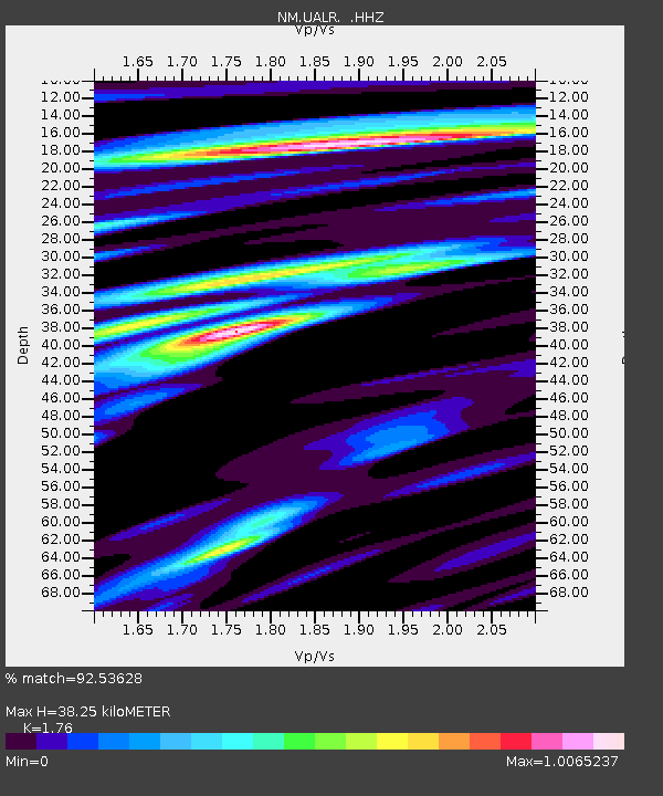
| Estimated Moho Depth: |
38.25 km |
| Estimated Crust Vp/Vs: |
1.76 |
| Assumed Crust Vp: |
6.498 km/s |
| Estimated Crust Vs: |
3.692 km/s |
| Estimated Crust Poisson's Ratio: |
0.26 |
|
| Radial Match: |
92.53628 % |
| Radial Bump: |
400 |
| Transverse Match: |
73.62501 % |
| Transverse Bump: |
400 |
| SOD ConfigId: |
512894 |
| Insert Time: |
2013-09-13 11:25:08.731 +0000 |
| GWidth: |
2.5 |
| Max Bumps: |
400 |
| Tol: |
0.001 |
|

Signal To Noise
| Channel | StoN | STA | LTA |
| NM:UALR: :HHZ:20130419T03:17:25.988013Z | 27.425438 | 3.3703022E-6 | 1.2288965E-7 |
| NM:UALR: :HHN:20130419T03:17:25.988013Z | 7.3610845 | 1.1710292E-6 | 1.590838E-7 |
| NM:UALR: :HHE:20130419T03:17:25.988013Z | 3.9082177 | 8.13037E-7 | 2.0803269E-7 |
| Arrivals |
| Ps | 4.6 SECOND |
| PpPs | 16 SECOND |
| PsPs/PpSs | 20 SECOND |


