You are here: Home > Network List > XO11 - Ozark Illinois, Indiana and Kentucky ES Flexible Array Stations List
> Station KG35 KG35 of OIINK Flexarray > Earthquake Result Viewer
KG35 KG35 of OIINK Flexarray - Earthquake Result Viewer
| Earthquake location: |
Kuril Islands |
| Earthquake latitude/longitude: |
44.6/148.7 |
| Earthquake time(UTC): |
2014/07/20 (201) 18:32:47 GMT |
| Earthquake Depth: |
61 km |
| Earthquake Magnitude: |
6.6 MB |
| Earthquake Catalog/Contributor: |
NEIC PDE/NEIC COMCAT |
|
| Network: |
XO Ozark Illinois, Indiana and Kentucky ES Flexible Array |
| Station: |
KG35 KG35 of OIINK Flexarray |
| Lat/Lon: |
37.64 N/86.61 W |
| Elevation: |
164 m |
|
| Distance: |
84.1 deg |
| Az: |
41.032 deg |
| Baz: |
323.805 deg |
| Ray Param: |
0.045634404 |
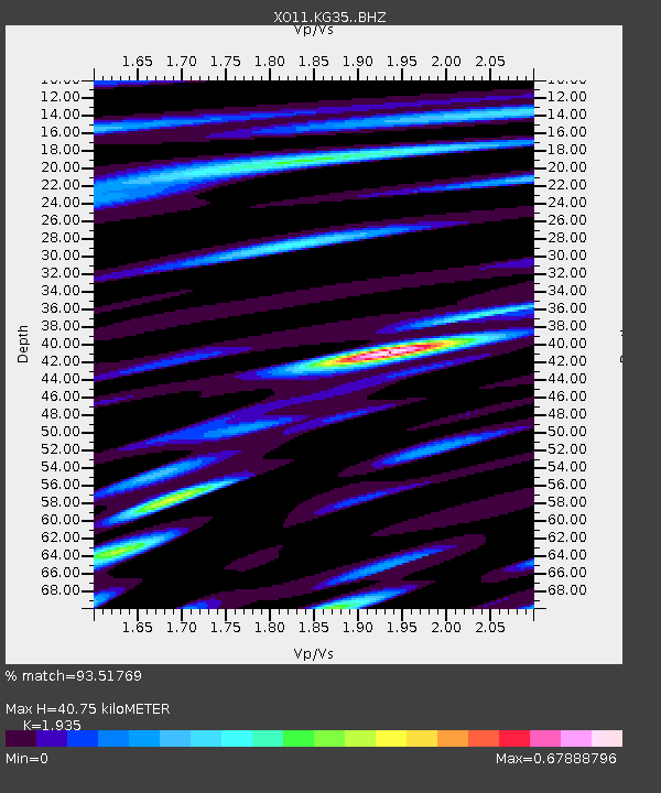
| Estimated Moho Depth: |
40.75 km |
| Estimated Crust Vp/Vs: |
1.93 |
| Assumed Crust Vp: |
6.444 km/s |
| Estimated Crust Vs: |
3.33 km/s |
| Estimated Crust Poisson's Ratio: |
0.32 |
|
| Radial Match: |
93.51769 % |
| Radial Bump: |
400 |
| Transverse Match: |
80.78883 % |
| Transverse Bump: |
400 |
| SOD ConfigId: |
3390531 |
| Insert Time: |
2019-04-12 23:38:11.748 +0000 |
| GWidth: |
2.5 |
| Max Bumps: |
400 |
| Tol: |
0.001 |
|

Signal To Noise
| Channel | StoN | STA | LTA |
| XO:KG35: :BHZ:20140720T18:44:40.545027Z | 36.187984 | 3.2198718E-6 | 8.897627E-8 |
| XO:KG35: :BHN:20140720T18:44:40.545027Z | 15.340828 | 9.509016E-7 | 6.198503E-8 |
| XO:KG35: :BHE:20140720T18:44:40.545027Z | 7.3424277 | 7.5500895E-7 | 1.02828245E-7 |
| Arrivals |
| Ps | 6.1 SECOND |
| PpPs | 18 SECOND |
| PsPs/PpSs | 24 SECOND |


