You are here: Home > Network List > NV - Neptune Canada Stations List
> Station NC27 Node ODP1027, BC > Earthquake Result Viewer
NC27 Node ODP1027, BC - Earthquake Result Viewer
| Earthquake location: |
Kuril Islands |
| Earthquake latitude/longitude: |
46.2/150.8 |
| Earthquake time(UTC): |
2013/04/19 (109) 03:05:52 GMT |
| Earthquake Depth: |
110 km |
| Earthquake Magnitude: |
7.2 MW, 7.1 MB, 7.2 MW |
| Earthquake Catalog/Contributor: |
NEIC PDE/NEIC PDE-W |
|
| Network: |
NV Neptune Canada |
| Station: |
NC27 Node ODP1027, BC |
| Lat/Lon: |
47.76 N/127.76 W |
| Elevation: |
-2656.0 m |
|
| Distance: |
53.1 deg |
| Az: |
56.577 deg |
| Baz: |
300.807 deg |
| Ray Param: |
0.06598613 |
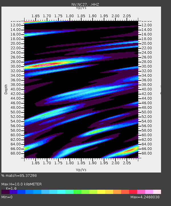
| Estimated Moho Depth: |
10.0 km |
| Estimated Crust Vp/Vs: |
1.60 |
| Assumed Crust Vp: |
6.183 km/s |
| Estimated Crust Vs: |
3.864 km/s |
| Estimated Crust Poisson's Ratio: |
0.18 |
|
| Radial Match: |
85.37298 % |
| Radial Bump: |
369 |
| Transverse Match: |
64.67806 % |
| Transverse Bump: |
400 |
| SOD ConfigId: |
512894 |
| Insert Time: |
2013-09-13 11:26:19.681 +0000 |
| GWidth: |
2.5 |
| Max Bumps: |
400 |
| Tol: |
0.001 |
|

Signal To Noise
| Channel | StoN | STA | LTA |
| NV:NC27: :HHZ:20130419T03:14:28.019995Z | 3.1550157 | 3.7205976E-7 | 1.1792643E-7 |
| NV:NC27: :HHN:20130419T03:14:28.019995Z | 1.1099885 | 5.212081E-7 | 4.6956174E-7 |
| NV:NC27: :HHE:20130419T03:14:28.019995Z | 1.1759387 | 5.495884E-7 | 4.6736142E-7 |
| Arrivals |
| Ps | 1.0 SECOND |
| PpPs | 4.0 SECOND |
| PsPs/PpSs | 5.0 SECOND |


