You are here: Home > Network List > PB - Plate Boundary Observatory Borehole Seismic Network Stations List
> Station B088 skyoks088bcs2007, Anza, CA, USA > Earthquake Result Viewer
B088 skyoks088bcs2007, Anza, CA, USA - Earthquake Result Viewer
| Earthquake location: |
Kuril Islands |
| Earthquake latitude/longitude: |
46.2/150.8 |
| Earthquake time(UTC): |
2013/04/19 (109) 03:05:52 GMT |
| Earthquake Depth: |
110 km |
| Earthquake Magnitude: |
7.2 MW, 7.1 MB, 7.2 MW |
| Earthquake Catalog/Contributor: |
NEIC PDE/NEIC PDE-W |
|
| Network: |
PB Plate Boundary Observatory Borehole Seismic Network |
| Station: |
B088 skyoks088bcs2007, Anza, CA, USA |
| Lat/Lon: |
33.37 N/116.62 W |
| Elevation: |
1404 m |
|
| Distance: |
68.4 deg |
| Az: |
64.018 deg |
| Baz: |
311.766 deg |
| Ray Param: |
0.05603135 |
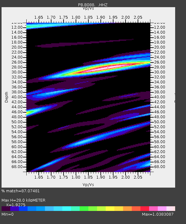
| Estimated Moho Depth: |
28.0 km |
| Estimated Crust Vp/Vs: |
1.93 |
| Assumed Crust Vp: |
6.264 km/s |
| Estimated Crust Vs: |
3.25 km/s |
| Estimated Crust Poisson's Ratio: |
0.32 |
|
| Radial Match: |
87.07481 % |
| Radial Bump: |
400 |
| Transverse Match: |
79.08925 % |
| Transverse Bump: |
400 |
| SOD ConfigId: |
512894 |
| Insert Time: |
2013-09-13 11:26:58.824 +0000 |
| GWidth: |
2.5 |
| Max Bumps: |
400 |
| Tol: |
0.001 |
|

Signal To Noise
| Channel | StoN | STA | LTA |
| PB:B088: :HHZ:20130419T03:16:11.798987Z | 30.126268 | 8.258847E-8 | 2.7414107E-9 |
| PB:B088: :HH1:20130419T03:16:11.798987Z | 6.40733 | 1.3059879E-8 | 2.0382716E-9 |
| PB:B088: :HH2:20130419T03:16:11.798987Z | 11.847317 | 2.5803592E-8 | 2.1780115E-9 |
| Arrivals |
| Ps | 4.3 SECOND |
| PpPs | 13 SECOND |
| PsPs/PpSs | 17 SECOND |


