You are here: Home > Network List > PM - Portuguese National Seismic Network Stations List
> Station PFVI PM.PFVI > Earthquake Result Viewer
PFVI PM.PFVI - Earthquake Result Viewer
| Earthquake location: |
Kuril Islands |
| Earthquake latitude/longitude: |
46.2/150.8 |
| Earthquake time(UTC): |
2013/04/19 (109) 03:05:52 GMT |
| Earthquake Depth: |
110 km |
| Earthquake Magnitude: |
7.2 MW, 7.1 MB, 7.2 MW |
| Earthquake Catalog/Contributor: |
NEIC PDE/NEIC PDE-W |
|
| Network: |
PM Portuguese National Seismic Network |
| Station: |
PFVI PM.PFVI |
| Lat/Lon: |
37.13 N/8.83 W |
| Elevation: |
189 m |
|
| Distance: |
95.0 deg |
| Az: |
343.773 deg |
| Baz: |
14.05 deg |
| Ray Param: |
0.040813416 |
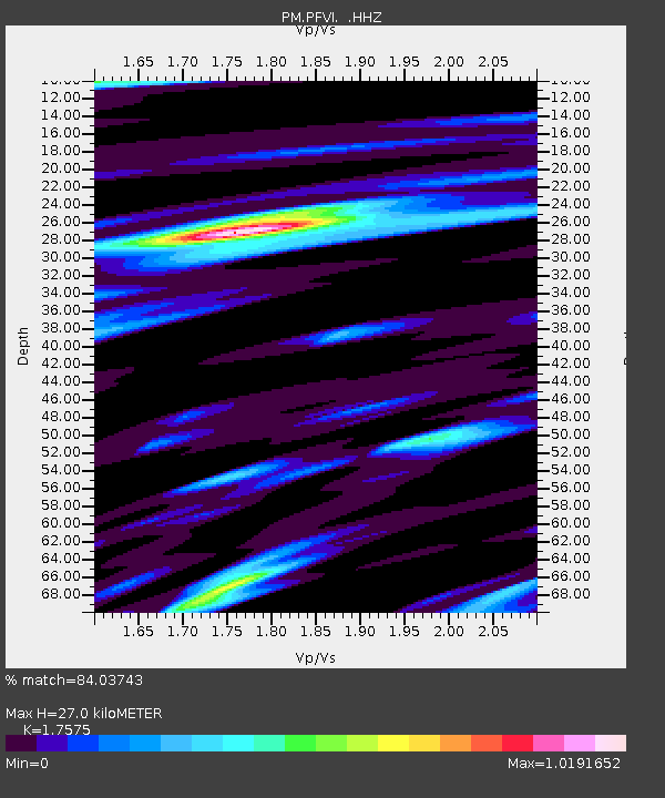
| Estimated Moho Depth: |
27.0 km |
| Estimated Crust Vp/Vs: |
1.76 |
| Assumed Crust Vp: |
6.048 km/s |
| Estimated Crust Vs: |
3.441 km/s |
| Estimated Crust Poisson's Ratio: |
0.26 |
|
| Radial Match: |
84.03743 % |
| Radial Bump: |
400 |
| Transverse Match: |
70.44445 % |
| Transverse Bump: |
400 |
| SOD ConfigId: |
512894 |
| Insert Time: |
2013-09-13 11:27:40.270 +0000 |
| GWidth: |
2.5 |
| Max Bumps: |
400 |
| Tol: |
0.001 |
|

Signal To Noise
| Channel | StoN | STA | LTA |
| PM:PFVI: :HHZ:20130419T03:18:31.579993Z | 3.0909774 | 2.1324227E-6 | 6.8988624E-7 |
| PM:PFVI: :HHN:20130419T03:18:31.579993Z | 1.6355942 | 7.4787897E-7 | 4.5725213E-7 |
| PM:PFVI: :HHE:20130419T03:18:31.579993Z | 0.718232 | 3.7110533E-7 | 5.1669286E-7 |
| Arrivals |
| Ps | 3.4 SECOND |
| PpPs | 12 SECOND |
| PsPs/PpSs | 16 SECOND |


