You are here: Home > Network List > PM - Portuguese National Seismic Network Stations List
> Station PESTR ESTREMOZ, PORTUGAL > Earthquake Result Viewer
PESTR ESTREMOZ, PORTUGAL - Earthquake Result Viewer
| Earthquake location: |
Kuril Islands |
| Earthquake latitude/longitude: |
46.2/150.8 |
| Earthquake time(UTC): |
2013/04/19 (109) 03:05:52 GMT |
| Earthquake Depth: |
110 km |
| Earthquake Magnitude: |
7.2 MW, 7.1 MB, 7.2 MW |
| Earthquake Catalog/Contributor: |
NEIC PDE/NEIC PDE-W |
|
| Network: |
PM Portuguese National Seismic Network |
| Station: |
PESTR ESTREMOZ, PORTUGAL |
| Lat/Lon: |
38.87 N/7.59 W |
| Elevation: |
410 m |
|
| Distance: |
93.1 deg |
| Az: |
343.257 deg |
| Baz: |
14.845 deg |
| Ray Param: |
0.0412674 |
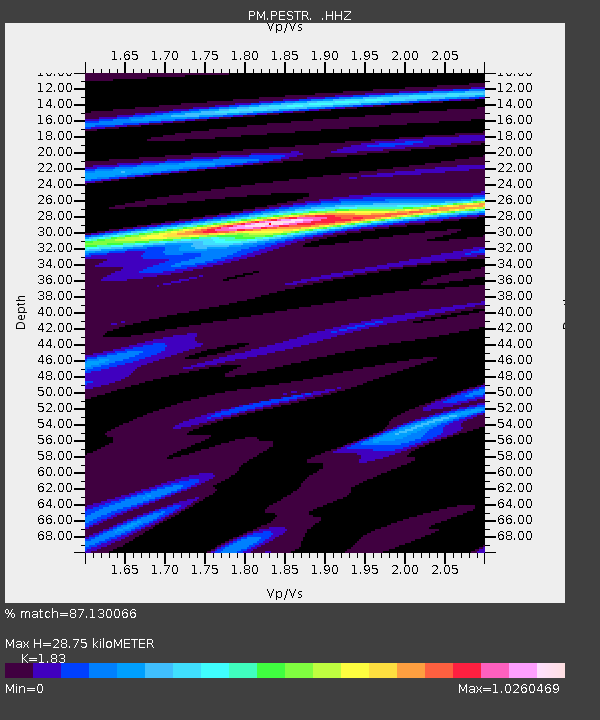
| Estimated Moho Depth: |
28.75 km |
| Estimated Crust Vp/Vs: |
1.83 |
| Assumed Crust Vp: |
6.276 km/s |
| Estimated Crust Vs: |
3.429 km/s |
| Estimated Crust Poisson's Ratio: |
0.29 |
|
| Radial Match: |
87.130066 % |
| Radial Bump: |
361 |
| Transverse Match: |
65.88141 % |
| Transverse Bump: |
400 |
| SOD ConfigId: |
512894 |
| Insert Time: |
2013-09-13 11:27:41.359 +0000 |
| GWidth: |
2.5 |
| Max Bumps: |
400 |
| Tol: |
0.001 |
|

Signal To Noise
| Channel | StoN | STA | LTA |
| PM:PESTR: :HHZ:20130419T03:18:22.829993Z | 5.0931444 | 1.8220735E-6 | 3.5775022E-7 |
| PM:PESTR: :HHN:20130419T03:18:22.829993Z | 2.1177466 | 6.3050953E-7 | 2.9772661E-7 |
| PM:PESTR: :HHE:20130419T03:18:22.829993Z | 1.4982307 | 3.2583543E-7 | 2.1748015E-7 |
| Arrivals |
| Ps | 3.9 SECOND |
| PpPs | 13 SECOND |
| PsPs/PpSs | 17 SECOND |


