You are here: Home > Network List > XO11 - Ozark Illinois, Indiana and Kentucky ES Flexible Array Stations List
> Station KK42 KK42 of OIINK Flexarray > Earthquake Result Viewer
KK42 KK42 of OIINK Flexarray - Earthquake Result Viewer
| Earthquake location: |
Kuril Islands |
| Earthquake latitude/longitude: |
44.6/148.7 |
| Earthquake time(UTC): |
2014/07/20 (201) 18:32:47 GMT |
| Earthquake Depth: |
61 km |
| Earthquake Magnitude: |
6.6 MB |
| Earthquake Catalog/Contributor: |
NEIC PDE/NEIC COMCAT |
|
| Network: |
XO Ozark Illinois, Indiana and Kentucky ES Flexible Array |
| Station: |
KK42 KK42 of OIINK Flexarray |
| Lat/Lon: |
36.90 N/85.74 W |
| Elevation: |
259 m |
|
| Distance: |
85.1 deg |
| Az: |
40.9 deg |
| Baz: |
324.32 deg |
| Ray Param: |
0.044915203 |
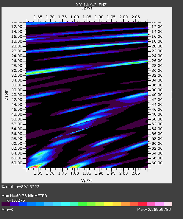
| Estimated Moho Depth: |
69.75 km |
| Estimated Crust Vp/Vs: |
1.63 |
| Assumed Crust Vp: |
6.476 km/s |
| Estimated Crust Vs: |
3.979 km/s |
| Estimated Crust Poisson's Ratio: |
0.20 |
|
| Radial Match: |
80.13222 % |
| Radial Bump: |
400 |
| Transverse Match: |
56.062244 % |
| Transverse Bump: |
400 |
| SOD ConfigId: |
3390531 |
| Insert Time: |
2019-04-12 23:38:47.482 +0000 |
| GWidth: |
2.5 |
| Max Bumps: |
400 |
| Tol: |
0.001 |
|

Signal To Noise
| Channel | StoN | STA | LTA |
| XO:KK42: :BHZ:20140720T18:44:45.595015Z | 52.683933 | 4.524424E-6 | 8.587863E-8 |
| XO:KK42: :BHN:20140720T18:44:45.595015Z | 4.4148207 | 1.3632126E-6 | 3.0878095E-7 |
| XO:KK42: :BHE:20140720T18:44:45.595015Z | 7.3843465 | 7.2847973E-7 | 9.8651896E-8 |
| Arrivals |
| Ps | 6.9 SECOND |
| PpPs | 28 SECOND |
| PsPs/PpSs | 34 SECOND |


