You are here: Home > Network List > PO - Portable Observatories for Lithospheric Analysis and Research Investigating Seis Stations List
> Station DELO DELORO MINE, ON > Earthquake Result Viewer
DELO DELORO MINE, ON - Earthquake Result Viewer
| Earthquake location: |
Kuril Islands |
| Earthquake latitude/longitude: |
46.2/150.8 |
| Earthquake time(UTC): |
2013/04/19 (109) 03:05:52 GMT |
| Earthquake Depth: |
110 km |
| Earthquake Magnitude: |
7.2 MW, 7.1 MB, 7.2 MW |
| Earthquake Catalog/Contributor: |
NEIC PDE/NEIC PDE-W |
|
| Network: |
PO Portable Observatories for Lithospheric Analysis and Research Investigating Seis |
| Station: |
DELO DELORO MINE, ON |
| Lat/Lon: |
44.52 N/77.62 W |
| Elevation: |
213 m |
|
| Distance: |
80.0 deg |
| Az: |
32.903 deg |
| Baz: |
328.183 deg |
| Ray Param: |
0.048307646 |
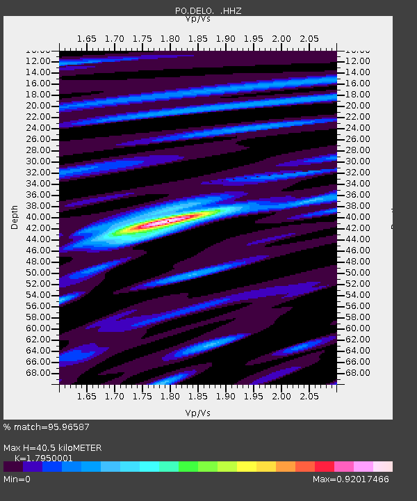
| Estimated Moho Depth: |
40.5 km |
| Estimated Crust Vp/Vs: |
1.80 |
| Assumed Crust Vp: |
6.577 km/s |
| Estimated Crust Vs: |
3.664 km/s |
| Estimated Crust Poisson's Ratio: |
0.27 |
|
| Radial Match: |
95.96587 % |
| Radial Bump: |
342 |
| Transverse Match: |
86.46202 % |
| Transverse Bump: |
400 |
| SOD ConfigId: |
512894 |
| Insert Time: |
2013-09-13 11:28:26.220 +0000 |
| GWidth: |
2.5 |
| Max Bumps: |
400 |
| Tol: |
0.001 |
|

Signal To Noise
| Channel | StoN | STA | LTA |
| PO:DELO: :HHZ:20130419T03:17:18.959998Z | 24.296223 | 1.7795304E-6 | 7.3243086E-8 |
| PO:DELO: :HHN:20130419T03:17:18.959998Z | 11.741336 | 5.553607E-7 | 4.7299622E-8 |
| PO:DELO: :HHE:20130419T03:17:18.959998Z | 5.1862364 | 3.122395E-7 | 6.020541E-8 |
| Arrivals |
| Ps | 5.0 SECOND |
| PpPs | 17 SECOND |
| PsPs/PpSs | 22 SECOND |


