You are here: Home > Network List > PO - Portable Observatories for Lithospheric Analysis and Research Investigating Seis Stations List
> Station PLIO PELEE ISLAND, ON > Earthquake Result Viewer
PLIO PELEE ISLAND, ON - Earthquake Result Viewer
| Earthquake location: |
Kuril Islands |
| Earthquake latitude/longitude: |
46.2/150.8 |
| Earthquake time(UTC): |
2013/04/19 (109) 03:05:52 GMT |
| Earthquake Depth: |
110 km |
| Earthquake Magnitude: |
7.2 MW, 7.1 MB, 7.2 MW |
| Earthquake Catalog/Contributor: |
NEIC PDE/NEIC PDE-W |
|
| Network: |
PO Portable Observatories for Lithospheric Analysis and Research Investigating Seis |
| Station: |
PLIO PELEE ISLAND, ON |
| Lat/Lon: |
41.75 N/82.63 W |
| Elevation: |
143 m |
|
| Distance: |
80.3 deg |
| Az: |
37.553 deg |
| Baz: |
325.561 deg |
| Ray Param: |
0.048097964 |
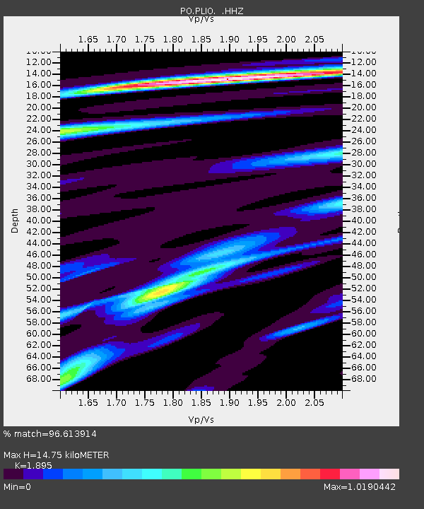
| Estimated Moho Depth: |
14.75 km |
| Estimated Crust Vp/Vs: |
1.89 |
| Assumed Crust Vp: |
6.498 km/s |
| Estimated Crust Vs: |
3.429 km/s |
| Estimated Crust Poisson's Ratio: |
0.31 |
|
| Radial Match: |
96.613914 % |
| Radial Bump: |
278 |
| Transverse Match: |
90.34861 % |
| Transverse Bump: |
400 |
| SOD ConfigId: |
512894 |
| Insert Time: |
2013-09-13 11:29:16.493 +0000 |
| GWidth: |
2.5 |
| Max Bumps: |
400 |
| Tol: |
0.001 |
|

Signal To Noise
| Channel | StoN | STA | LTA |
| PO:PLIO: :HHZ:20130419T03:17:20.619971Z | 30.49618 | 1.938867E-6 | 6.3577374E-8 |
| PO:PLIO: :HHN:20130419T03:17:20.619971Z | 10.899528 | 5.844266E-7 | 5.361944E-8 |
| PO:PLIO: :HHE:20130419T03:17:20.619971Z | 5.2429533 | 4.117277E-7 | 7.852973E-8 |
| Arrivals |
| Ps | 2.1 SECOND |
| PpPs | 6.4 SECOND |
| PsPs/PpSs | 8.5 SECOND |


