You are here: Home > Network List > PO - Portable Observatories for Lithospheric Analysis and Research Investigating Seis Stations List
> Station PLVO PLEVNA, ON > Earthquake Result Viewer
PLVO PLEVNA, ON - Earthquake Result Viewer
| Earthquake location: |
Kuril Islands |
| Earthquake latitude/longitude: |
46.2/150.8 |
| Earthquake time(UTC): |
2013/04/19 (109) 03:05:52 GMT |
| Earthquake Depth: |
110 km |
| Earthquake Magnitude: |
7.2 MW, 7.1 MB, 7.2 MW |
| Earthquake Catalog/Contributor: |
NEIC PDE/NEIC PDE-W |
|
| Network: |
PO Portable Observatories for Lithospheric Analysis and Research Investigating Seis |
| Station: |
PLVO PLEVNA, ON |
| Lat/Lon: |
45.04 N/77.08 W |
| Elevation: |
0.0 m |
|
| Distance: |
79.8 deg |
| Az: |
32.29 deg |
| Baz: |
328.457 deg |
| Ray Param: |
0.04847143 |
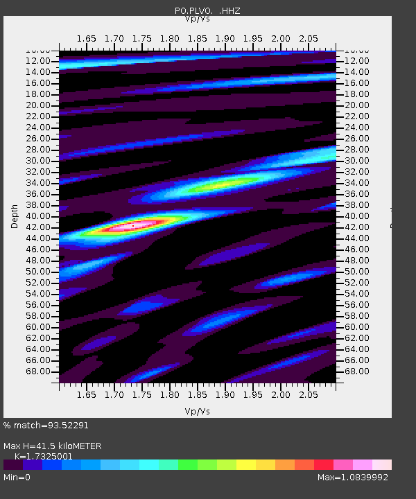
| Estimated Moho Depth: |
41.5 km |
| Estimated Crust Vp/Vs: |
1.73 |
| Assumed Crust Vp: |
6.577 km/s |
| Estimated Crust Vs: |
3.796 km/s |
| Estimated Crust Poisson's Ratio: |
0.25 |
|
| Radial Match: |
93.52291 % |
| Radial Bump: |
400 |
| Transverse Match: |
86.703964 % |
| Transverse Bump: |
400 |
| SOD ConfigId: |
512894 |
| Insert Time: |
2013-09-13 11:29:19.214 +0000 |
| GWidth: |
2.5 |
| Max Bumps: |
400 |
| Tol: |
0.001 |
|

Signal To Noise
| Channel | StoN | STA | LTA |
| PO:PLVO: :HHZ:20130419T03:17:17.66001Z | 24.84274 | 1.7263428E-6 | 6.949084E-8 |
| PO:PLVO: :HHN:20130419T03:17:17.66001Z | 6.014526 | 4.130301E-7 | 6.8672094E-8 |
| PO:PLVO: :HHE:20130419T03:17:17.66001Z | 8.762769 | 5.531795E-7 | 6.312839E-8 |
| Arrivals |
| Ps | 4.8 SECOND |
| PpPs | 17 SECOND |
| PsPs/PpSs | 21 SECOND |


