You are here: Home > Network List > TA - USArray Transportable Network (new EarthScope stations) Stations List
> Station 058A Arcadia, FL, USA > Earthquake Result Viewer
058A Arcadia, FL, USA - Earthquake Result Viewer
| Earthquake location: |
Kuril Islands |
| Earthquake latitude/longitude: |
46.2/150.8 |
| Earthquake time(UTC): |
2013/04/19 (109) 03:05:52 GMT |
| Earthquake Depth: |
110 km |
| Earthquake Magnitude: |
7.2 MW, 7.1 MB, 7.2 MW |
| Earthquake Catalog/Contributor: |
NEIC PDE/NEIC PDE-W |
|
| Network: |
TA USArray Transportable Network (new EarthScope stations) |
| Station: |
058A Arcadia, FL, USA |
| Lat/Lon: |
27.06 N/81.80 W |
| Elevation: |
15 m |
|
| Distance: |
92.9 deg |
| Az: |
45.177 deg |
| Baz: |
326.481 deg |
| Ray Param: |
0.041308094 |
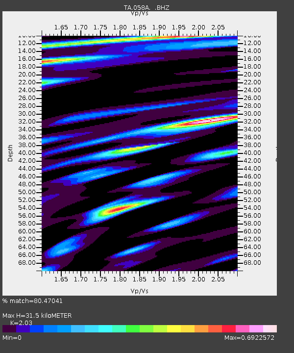
| Estimated Moho Depth: |
31.5 km |
| Estimated Crust Vp/Vs: |
2.03 |
| Assumed Crust Vp: |
6.347 km/s |
| Estimated Crust Vs: |
3.127 km/s |
| Estimated Crust Poisson's Ratio: |
0.34 |
|
| Radial Match: |
80.47041 % |
| Radial Bump: |
400 |
| Transverse Match: |
64.15305 % |
| Transverse Bump: |
400 |
| SOD ConfigId: |
512894 |
| Insert Time: |
2013-09-13 11:31:24.083 +0000 |
| GWidth: |
2.5 |
| Max Bumps: |
400 |
| Tol: |
0.001 |
|

Signal To Noise
| Channel | StoN | STA | LTA |
| TA:058A: :BHZ:20130419T03:18:21.900Z | 4.1979218 | 2.154984E-6 | 5.133454E-7 |
| TA:058A: :BHN:20130419T03:18:21.900Z | 1.6091484 | 4.9751253E-7 | 3.0917752E-7 |
| TA:058A: :BHE:20130419T03:18:21.900Z | 1.1175843 | 4.2174003E-7 | 3.7736754E-7 |
| Arrivals |
| Ps | 5.2 SECOND |
| PpPs | 15 SECOND |
| PsPs/PpSs | 20 SECOND |


