You are here: Home > Network List > TA - USArray Transportable Network (new EarthScope stations) Stations List
> Station 148A Greensboro, AL, USA > Earthquake Result Viewer
148A Greensboro, AL, USA - Earthquake Result Viewer
| Earthquake location: |
Kuril Islands |
| Earthquake latitude/longitude: |
46.2/150.8 |
| Earthquake time(UTC): |
2013/04/19 (109) 03:05:52 GMT |
| Earthquake Depth: |
110 km |
| Earthquake Magnitude: |
7.2 MW, 7.1 MB, 7.2 MW |
| Earthquake Catalog/Contributor: |
NEIC PDE/NEIC PDE-W |
|
| Network: |
TA USArray Transportable Network (new EarthScope stations) |
| Station: |
148A Greensboro, AL, USA |
| Lat/Lon: |
32.65 N/87.57 W |
| Elevation: |
63 m |
|
| Distance: |
85.5 deg |
| Az: |
46.096 deg |
| Baz: |
323.633 deg |
| Ray Param: |
0.044510014 |
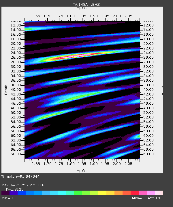
| Estimated Moho Depth: |
25.25 km |
| Estimated Crust Vp/Vs: |
1.81 |
| Assumed Crust Vp: |
6.565 km/s |
| Estimated Crust Vs: |
3.622 km/s |
| Estimated Crust Poisson's Ratio: |
0.28 |
|
| Radial Match: |
91.647644 % |
| Radial Bump: |
400 |
| Transverse Match: |
92.82632 % |
| Transverse Bump: |
400 |
| SOD ConfigId: |
512894 |
| Insert Time: |
2013-09-13 11:31:54.677 +0000 |
| GWidth: |
2.5 |
| Max Bumps: |
400 |
| Tol: |
0.001 |
|

Signal To Noise
| Channel | StoN | STA | LTA |
| TA:148A: :BHZ:20130419T03:17:46.925024Z | 21.921473 | 4.9481127E-6 | 2.2571992E-7 |
| TA:148A: :BHN:20130419T03:17:46.925024Z | 2.657044 | 1.9662768E-6 | 7.4002423E-7 |
| TA:148A: :BHE:20130419T03:17:46.925024Z | 3.7388222 | 1.2010546E-6 | 3.2123876E-7 |
| Arrivals |
| Ps | 3.2 SECOND |
| PpPs | 11 SECOND |
| PsPs/PpSs | 14 SECOND |


