You are here: Home > Network List > YB13 - Continental Dynamics/Cent. Anatolian Tectonics:Surface to Mantle Dynamics During Stations List
> Station AT48 Saylak,Hatay,Turkey > Earthquake Result Viewer
AT48 Saylak,Hatay,Turkey - Earthquake Result Viewer
| Earthquake location: |
Kuril Islands |
| Earthquake latitude/longitude: |
44.6/148.7 |
| Earthquake time(UTC): |
2014/07/20 (201) 18:32:47 GMT |
| Earthquake Depth: |
61 km |
| Earthquake Magnitude: |
6.6 MB |
| Earthquake Catalog/Contributor: |
NEIC PDE/NEIC COMCAT |
|
| Network: |
YB Continental Dynamics/Cent. Anatolian Tectonics:Surface to Mantle Dynamics During |
| Station: |
AT48 Saylak,Hatay,Turkey |
| Lat/Lon: |
36.62 N/36.41 E |
| Elevation: |
249 m |
|
| Distance: |
78.6 deg |
| Az: |
310.601 deg |
| Baz: |
42.368 deg |
| Ray Param: |
0.049412776 |
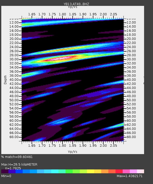
| Estimated Moho Depth: |
29.5 km |
| Estimated Crust Vp/Vs: |
1.78 |
| Assumed Crust Vp: |
6.247 km/s |
| Estimated Crust Vs: |
3.504 km/s |
| Estimated Crust Poisson's Ratio: |
0.27 |
|
| Radial Match: |
89.60461 % |
| Radial Bump: |
400 |
| Transverse Match: |
86.85052 % |
| Transverse Bump: |
400 |
| SOD ConfigId: |
3390531 |
| Insert Time: |
2019-04-12 23:39:31.900 +0000 |
| GWidth: |
2.5 |
| Max Bumps: |
400 |
| Tol: |
0.001 |
|

Signal To Noise
| Channel | StoN | STA | LTA |
| YB:AT48: :BHZ:20140720T18:44:12.038984Z | 27.894342 | 8.438966E-6 | 3.025332E-7 |
| YB:AT48: :BHN:20140720T18:44:12.038984Z | 3.1460466 | 1.9547615E-6 | 6.21339E-7 |
| YB:AT48: :BHE:20140720T18:44:12.038984Z | 5.0802164 | 2.0638445E-6 | 4.062513E-7 |
| Arrivals |
| Ps | 3.8 SECOND |
| PpPs | 13 SECOND |
| PsPs/PpSs | 17 SECOND |


