You are here: Home > Network List > TA - USArray Transportable Network (new EarthScope stations) Stations List
> Station 155A Kite, GA, USA > Earthquake Result Viewer
155A Kite, GA, USA - Earthquake Result Viewer
| Earthquake location: |
Kuril Islands |
| Earthquake latitude/longitude: |
46.2/150.8 |
| Earthquake time(UTC): |
2013/04/19 (109) 03:05:52 GMT |
| Earthquake Depth: |
110 km |
| Earthquake Magnitude: |
7.2 MW, 7.1 MB, 7.2 MW |
| Earthquake Catalog/Contributor: |
NEIC PDE/NEIC PDE-W |
|
| Network: |
TA USArray Transportable Network (new EarthScope stations) |
| Station: |
155A Kite, GA, USA |
| Lat/Lon: |
32.62 N/82.47 W |
| Elevation: |
93 m |
|
| Distance: |
88.0 deg |
| Az: |
42.581 deg |
| Baz: |
326.173 deg |
| Ray Param: |
0.04270788 |
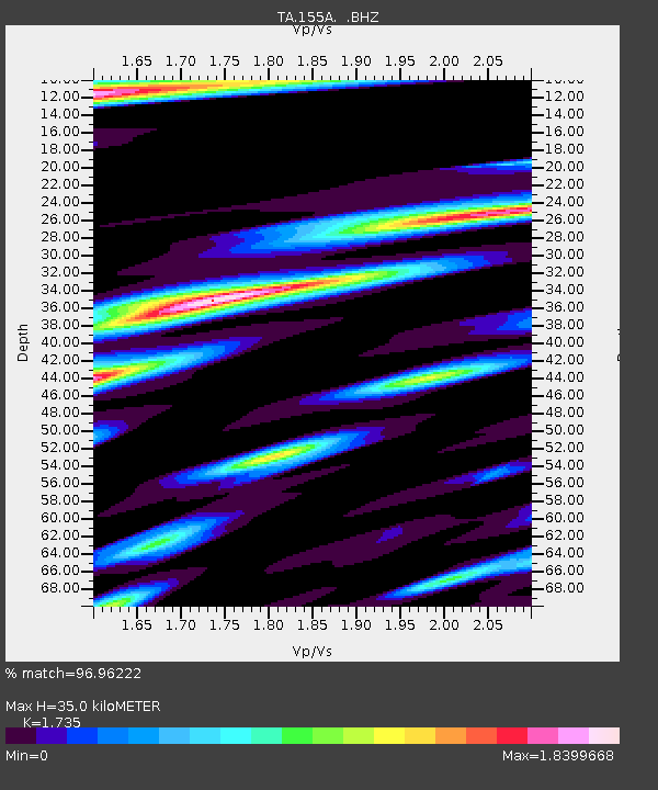
| Estimated Moho Depth: |
35.0 km |
| Estimated Crust Vp/Vs: |
1.74 |
| Assumed Crust Vp: |
6.565 km/s |
| Estimated Crust Vs: |
3.784 km/s |
| Estimated Crust Poisson's Ratio: |
0.25 |
|
| Radial Match: |
96.96222 % |
| Radial Bump: |
345 |
| Transverse Match: |
97.72999 % |
| Transverse Bump: |
297 |
| SOD ConfigId: |
512894 |
| Insert Time: |
2013-09-13 11:32:18.563 +0000 |
| GWidth: |
2.5 |
| Max Bumps: |
400 |
| Tol: |
0.001 |
|
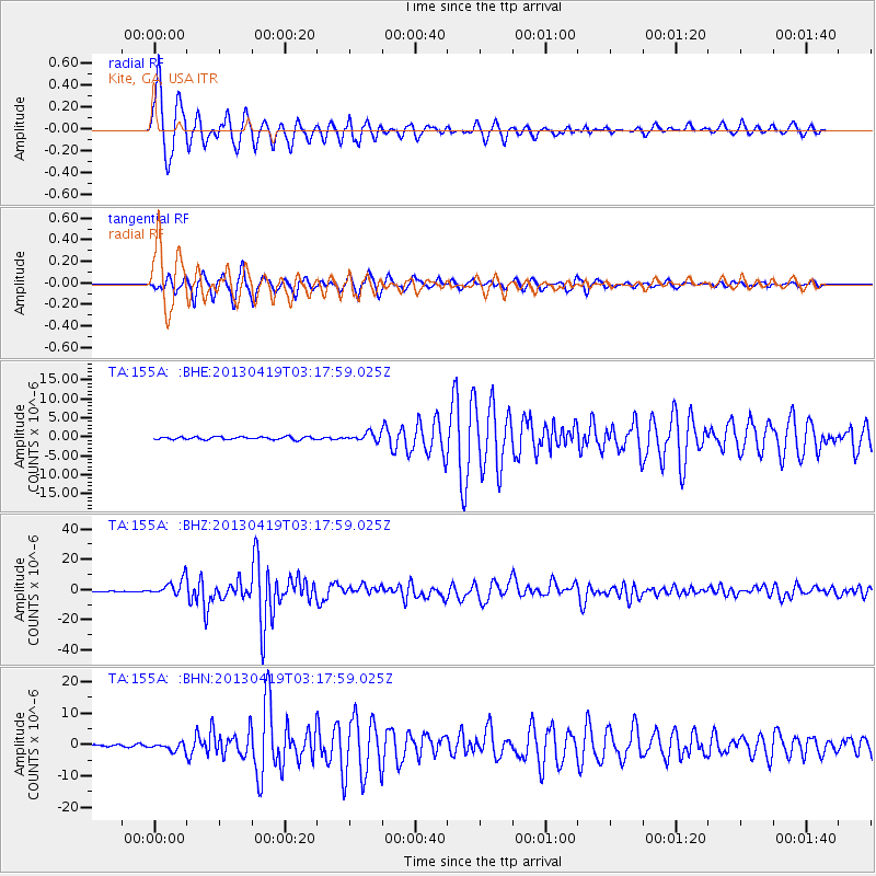
Signal To Noise
| Channel | StoN | STA | LTA |
| TA:155A: :BHZ:20130419T03:17:59.025Z | 25.752964 | 5.5003175E-6 | 2.1357998E-7 |
| TA:155A: :BHN:20130419T03:17:59.025Z | 3.7055352 | 1.2856262E-6 | 3.4694753E-7 |
| TA:155A: :BHE:20130419T03:17:59.025Z | 2.825136 | 1.0475724E-6 | 3.7080426E-7 |
| Arrivals |
| Ps | 4.0 SECOND |
| PpPs | 14 SECOND |
| PsPs/PpSs | 18 SECOND |


