You are here: Home > Network List > TA - USArray Transportable Network (new EarthScope stations) Stations List
> Station 249A Camden, AL, USA > Earthquake Result Viewer
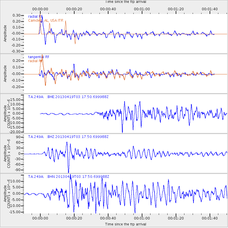
249A Camden, AL, USA - Earthquake Result Viewer
*The percent match for this event was below the threshold and hence no stack was calculated.
| Earthquake location: |
Kuril Islands |
| Earthquake latitude/longitude: |
46.2/150.8 |
| Earthquake time(UTC): |
2013/04/19 (109) 03:05:52 GMT |
| Earthquake Depth: |
110 km |
| Earthquake Magnitude: |
7.2 MW, 7.1 MB, 7.2 MW |
| Earthquake Catalog/Contributor: |
NEIC PDE/NEIC PDE-W |
|
| Network: |
TA USArray Transportable Network (new EarthScope stations) |
| Station: |
249A Camden, AL, USA |
| Lat/Lon: |
31.98 N/87.12 W |
| Elevation: |
66 m |
|
| Distance: |
86.2 deg |
| Az: |
46.186 deg |
| Baz: |
323.878 deg |
| Ray Param: |
$rayparam |
*The percent match for this event was below the threshold and hence was not used in the summary stack. |
|
| Radial Match: |
93.10383 % |
| Radial Bump: |
400 |
| Transverse Match: |
92.36591 % |
| Transverse Bump: |
400 |
| SOD ConfigId: |
512894 |
| Insert Time: |
2013-09-13 11:32:33.190 +0000 |
| GWidth: |
2.5 |
| Max Bumps: |
400 |
| Tol: |
0.001 |
|
Signal To Noise
| Channel | StoN | STA | LTA |
| TA:249A: :BHZ:20130419T03:17:50.699988Z | 59.320213 | 1.0320269E-5 | 1.739756E-7 |
| TA:249A: :BHN:20130419T03:17:50.699988Z | 3.9253008 | 1.2828056E-6 | 3.268044E-7 |
| TA:249A: :BHE:20130419T03:17:50.699988Z | 2.200676 | 1.0725269E-6 | 4.873624E-7 |
| Arrivals |
| Ps | |
| PpPs | |
| PsPs/PpSs | |


